By John J. King II
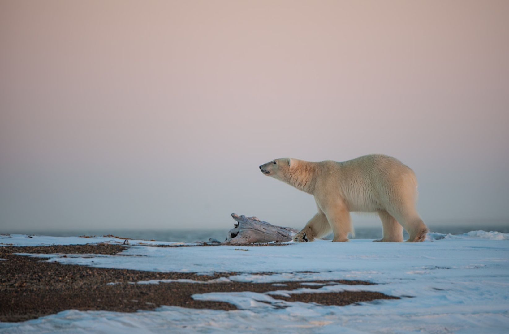
A polar bear (Ursus maritimus) walks the snow-and-gravel shore at Kaktovik in the low pink light of the Beaufort summer — the sea ice, on which four thousand years of northern life has depended, no longer reliably at his feet. Long before the whalers and the oil companies and the birders, the bear was already the sovereign of this coast; he is now a witness to its unmaking. Photograph by John J. King II.
I. The Solstice and the Edge
The flight from Anchorage to Nome takes you, in something under two hours, out of the version of America that congratulates itself on its roads and into a version that has never bothered with them — tundra, river deltas, the dull pewter glint of the Bering Sea pressing in on a peninsula that looks, from the window seat, less like a piece of a continent than like something the continent had been meaning to discard. You can only fly. The absence of a highway turns out to be a kind of moral fact, one of those rare American places where the question of whether the country should be here at all is still, faintly, open. The flight itself produced one of those gifts the mountain almost never gives: Denali, the whole twenty-thousand-foot bulk of it, ringed in a perfect collar of puffy cumulus and otherwise so cleanly visible that the passengers on the right side of the aircraft fell silent in the way passengers occasionally do when an airline accidentally delivers more than was advertised. Pam and I came in spring, as the shorebirds did — bar-tailed godwits dragging themselves up from New Zealand on the same air, red knots up from places it embarrasses a person to think about while sitting in a heated cabin eating peanuts — and within an hour of landing in Nome we were standing on a gravel pullout staring through a scope at a female gyrfalcon, the largest falcon on Earth, hunched at her cliff scrape over four downy chicks no more than a week old nested under a remote bridge nearby. She was the size of a small dog. The chicks were the size of tennis balls coated in dryer lint. She regarded us briefly, the way certain New York doormen regard certain guests, and then looked past us as if we had ceased, mercifully, to exist.
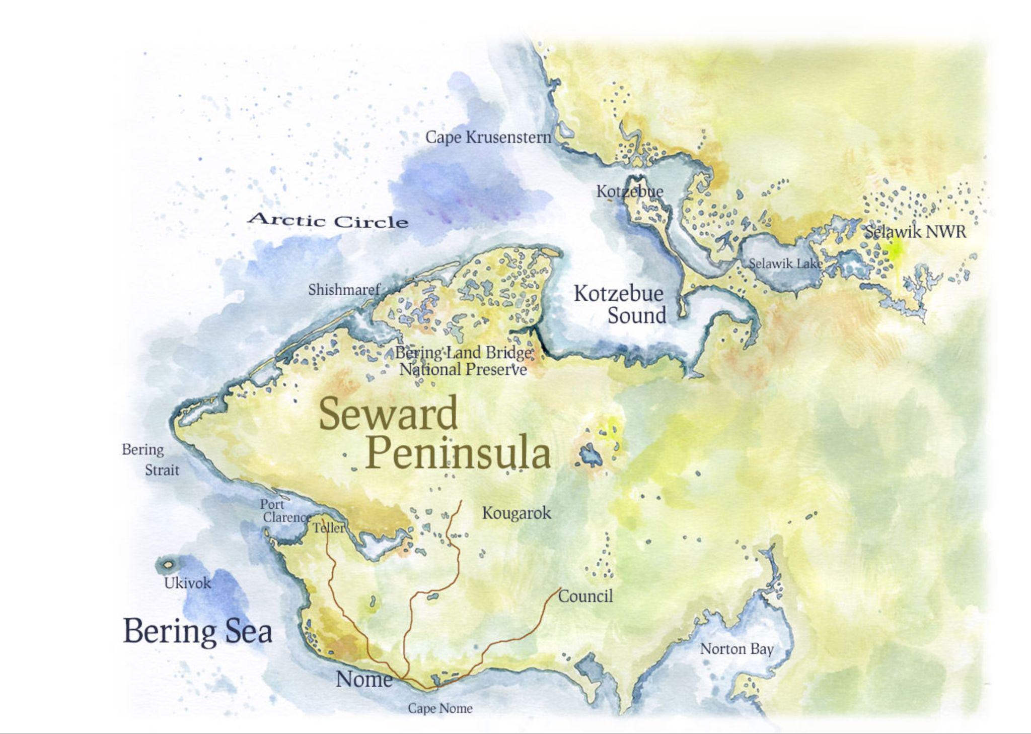
The Seward Peninsula — Nome at the south, the three gravel roads (Council, Kougarok, Teller) spidering inland, the Bering pressing in from the west and the Chukchi from the north. The peninsula juts toward Chukotka at a distance no whale has ever consulted. Map by Eric Gauger, "Midnight in Beringia".
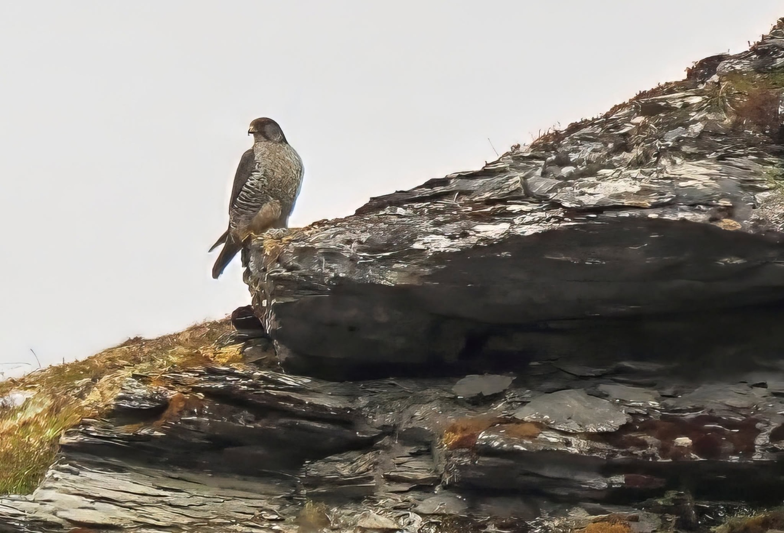
The female gyrfalcon on the slate outcrop above her scrape, near Nome, in early June. Four downy chicks were tucked into the ledge below the bridge; she watched us the way certain New York doormen watch certain guests. Photograph by John J. King II.
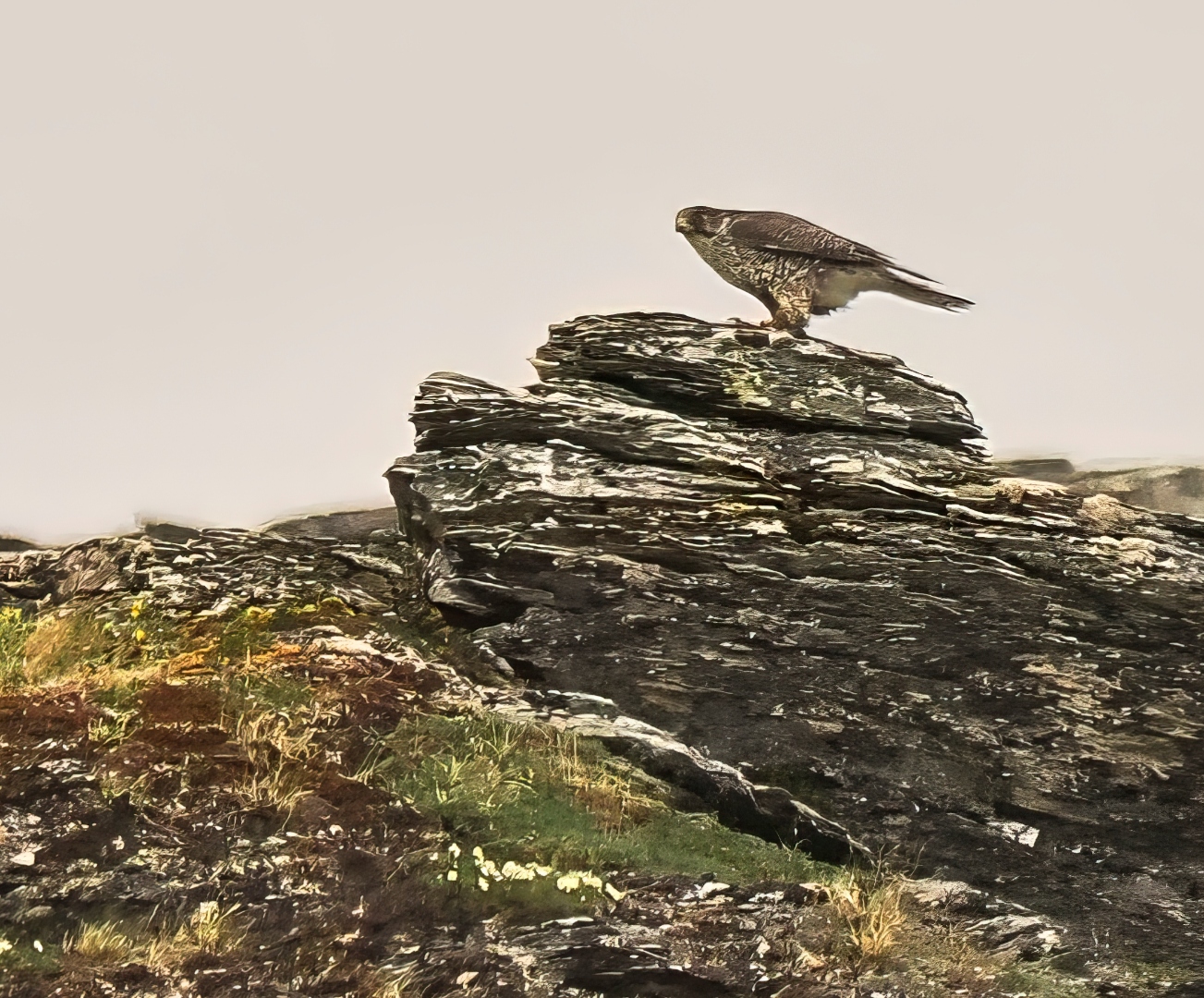
The same bird a moment later, lifting from the outcrop to hunt — the largest falcon on Earth, and the primary reason we came to Nome. Photograph by John J. King II.
The trip had been advertised, honestly enough, as a birding trip for avid birders, and most of our companions had never been to Alaska before. They had come for the list. They had come because the spectacled eider and the bristle-thighed curlew and the gyrfalcon and the bluethroat are checkboxes that cannot be filled in any other latitude of the United States, and twelve days, properly organized, can move a serious lifer's tally meaningfully closer to whatever number he or she has privately set as the goal of a lifetime in the field. By the end of the trip we would catalog 141 species, which is the kind of number a tour operator can put in a brochure with confidence and which, in the moment of writing it down each evening in a damp notebook, feels like the only number that matters.
It was not, of course, the only thing we saw. Denali had been the first instruction. The mountain held position as we tracked north — immobile, geological, twenty thousand feet of granite cooked out of the continent over sixty million years and unmoved by anything weather or politics had since attempted against it — the kind of presence that resets a person's sense of permanence for the rest of a trip. The instruction was, in the end, ironic. We were flying toward a coast at which permanence has been negotiated away, where the sea ice that organized four thousand years of Iñupiat life is in measurable retreat, where whole villages are now formally identified by the federal government as imminently doomed. Denali endures. Utqiaġvik does not, or will not on the schedule its inhabitants would prefer. The same window seat that showed us the mountain was carrying us, though none of us yet quite understood it, toward the place where America is losing ground in the most literal sense the word can hold.
The eiders, however, were going to make us wait, and they were going to make us wait farther north. We worked the gravel roads spidering out of Nome for days — the Council, the Kougarok, the Teller — pulling over at every black tundra pool where the wind had raked the cottongrass flat, the van filling with the particular smell of damp wool and instant coffee that one comes, on these trips, to associate with hope. The brief ode to the North Slope's spring revealed petite wildflowers, magnificent golden plovers, whimbrels still searching for an inviting nesting site, the prehistoric musk ox, and even a shiny golden-brown bear yearling that surprised us when we least expected it under sunny skies. The bristle-thighed curlew, however, evaded us even after traveling nearly seventy miles to a scouted nest location.
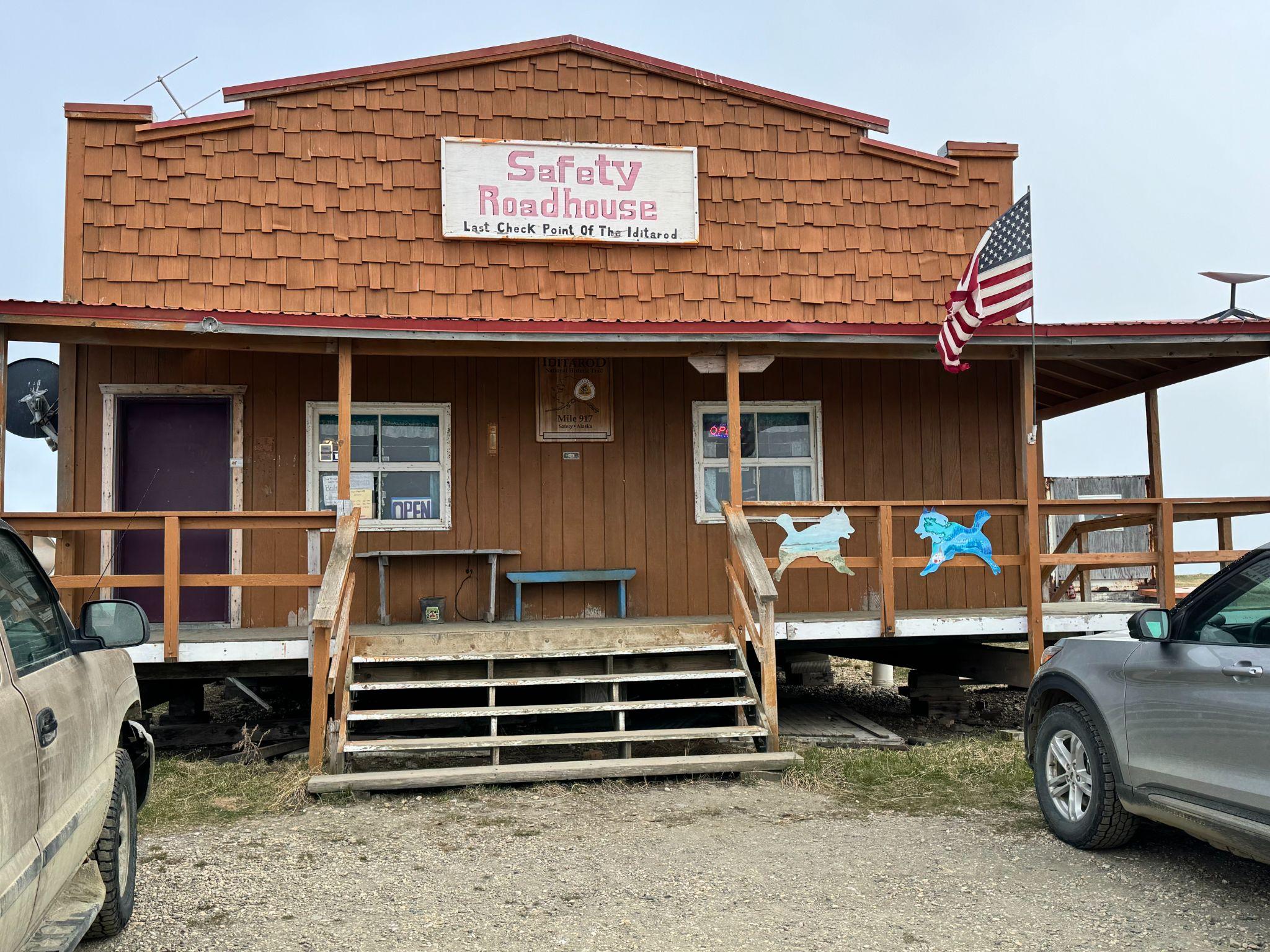
Safety Roadhouse on the Council Road east of Nome — one of the small, weather-beaten waypoints that punctuate the three gravel routes (Council, Kougarok, Teller) spidering out of town. The van filled with the smell of damp wool and instant coffee here; the whimbrels were another mile up the road. Photograph by John J. King II.
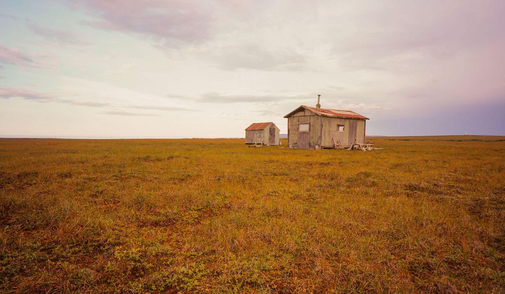
A working shack on the Nome road system — the small, unadorned architecture that the country tolerates because the country insists on being useful. Nothing here is decoration; every board serves a purpose the weather has already tested. Photograph by Eric Gauger, "Midnight in Beringia".
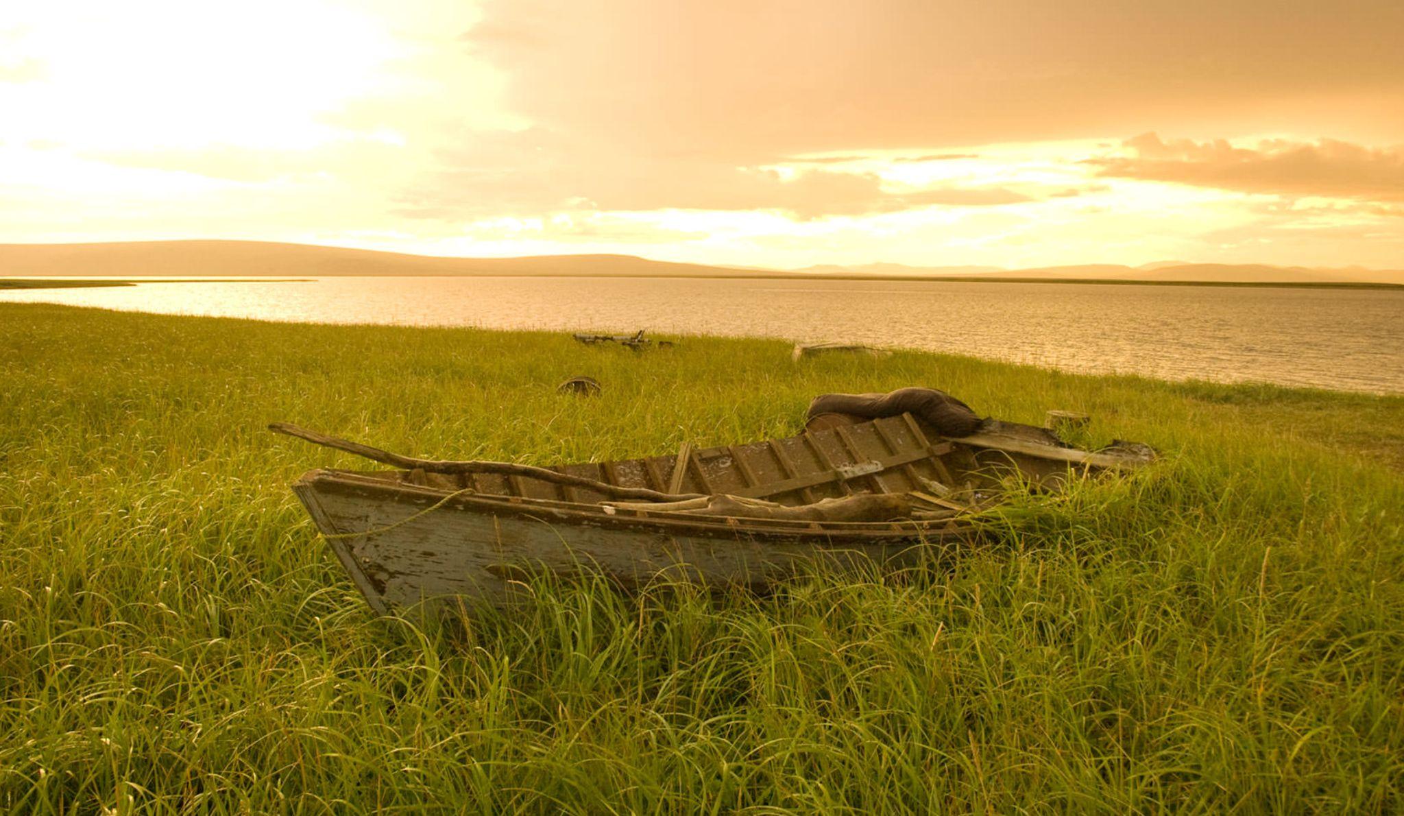
A small wooden rowboat pulled up in the tall tundra grass in the golden hour — the working boat of a subsistence economy the shorebird tour was, for twelve days, incidentally traveling across. The eiders were on a different pond a mile away; the boat had been at rest here for longer than the trip. Photograph by Eric Gauger, "Midnight in Beringia".
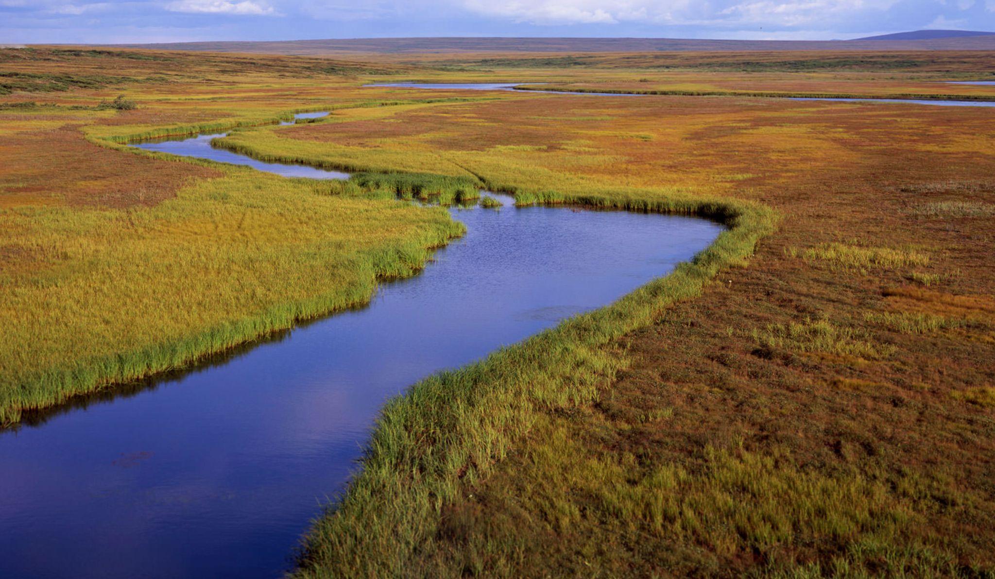
A braided tundra river working its slow way through the Seward Peninsula plain — the kind of watercourse that sets the flight paths of shorebirds and the summer range of caribou alike. The country reads, from a low pullout, as flat; the water is doing the actual work of shaping it. Photograph by Eric Gauger, "Midnight in Beringia".
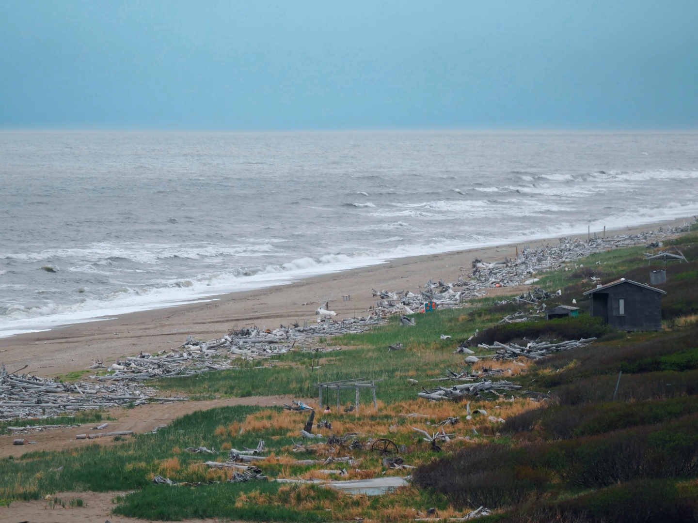
The Nome beach at low tide — miles of driftwood carried down by the Yukon and cast up by the Bering, small sheds nestled in the beach grass, the coast that briefly held twelve thousand men shovelling sand for gold. A century and a quarter later, a solitary shorebird works the wrack line where the miners once worked the sand. Photograph by John J. King II.
The official story of Nome, the one the cruise brochures tell, begins in September 1898, when Jafet Lindeberg, Erik Lindblom, and John Brynteson — the so-called Three Lucky Swedes, a name that already sounds like the title of a bad children's book — struck placer gold on Anvil Creek a few miles from what would become the town (National Park Service). Word reached the Klondike that winter; the following summer somebody noticed that the beach itself was gold, that you could literally shovel the sand into a rocker and come up with money, and Nome briefly became what the geological survey calls, with rare lyricism, "a poor man's paradise" (Alaska Division of Geological Surveys). By 1900 the tent city sprawled thirty miles down the coast and held more than 12,000 residents — the largest community in the Alaska Territory (Wikipedia). Between 1899 and 1910 the Seward Peninsula yielded roughly $46 million in gold — the last great American gold stampede, and like all stampedes a thing more interesting in the telling than in the consequences (NPS Cape Nome Landmark).
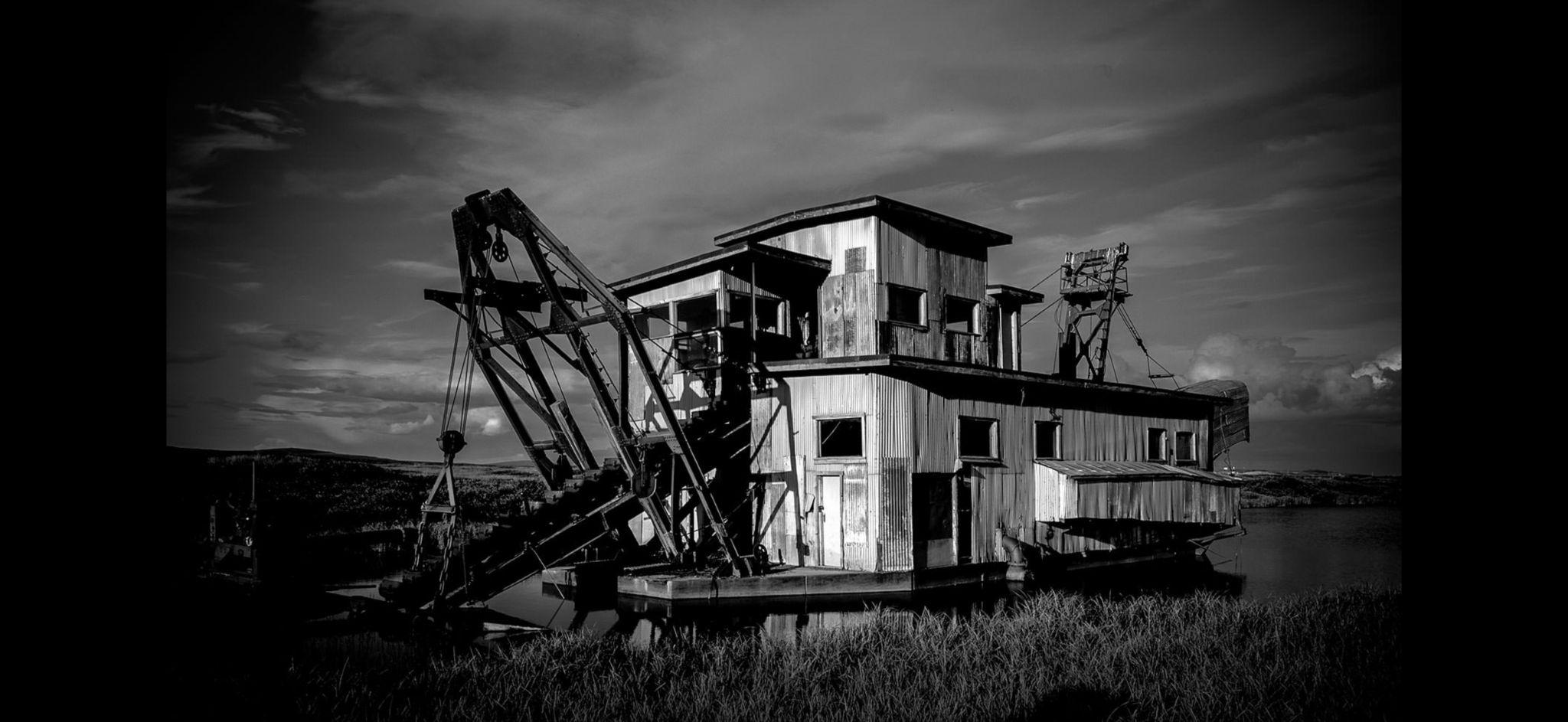
One of the abandoned bucket-line dredges rusting on the tundra outside Nome — the infrastructure the stampede left behind when the beach gold gave out. Between 1899 and 1910 the Seward Peninsula yielded roughly $46 million in gold, most of it moved by machines like this one; the tundra has been slowly repossessing the equipment ever since. Photograph by Eric Gauger, "Midnight in Beringia".
What the brochures do not say, because brochures do not say such things, is that Nome was not an empty beach when the Swedes arrived. In 2007 a routine archaeological dig by the U.S. Army Corps of Engineers turned up Iñupiaq house pits on the Snake River sandspit dating to roughly 1700 AD — three centuries before any Swede, lucky or otherwise, swung a pick on Anvil Creek (U.S. Army). The Iñupiat had hunted, fished, and gathered across the Seward Peninsula for thousands of years. The Nome visitor bureau, to its credit, now describes the gold rush as a brief chapter "set within the framework of 10,000 years of Inupiaq history," a sentence that does a lot of quiet work (Visit Nome Alaska). The town today is about 3,500 people and the supply hub for 26 outlying villages: a small, sober crossroads where Iñupiat, Yup'ik, and non-Native lives intersect with a casualness that is itself a kind of historical achievement.
Among the shorebirds working the Nome tundra that week was the whimbrel, a long-legged, long-billed migrant that one encounters in Alaska as a small bird against an enormous backdrop, calling its rolling seven-note alarm and probing the wet sedges with the studious indifference of an animal that has, somewhere in its calendar, larger appointments to keep. We watched several that week — most of them adults still hunting a nesting site, one a male standing sentinel on a low knoll with an air of mild proprietorship — and Pam, who has the better field eye between us, made a remark I have been turning over since, which was that the whimbrel did not look, on this tundra, like the same bird we knew from the New England coast. He looked at home. He looked unhurried. He looked, in other words, like a creature one does not normally meet at his actual address.
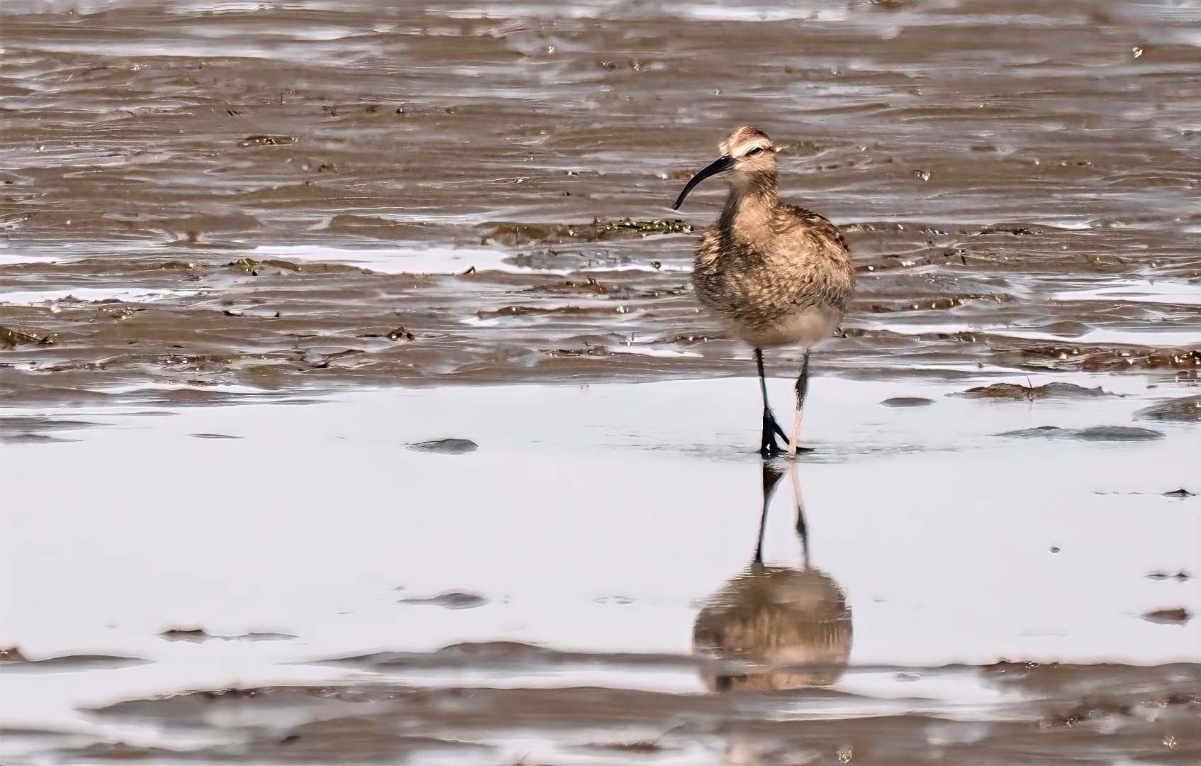
A whimbrel photographed six weeks earlier, in late April, on the mudflats of Grays Harbor, Washington — the same bird, or the same idea of a bird, staging on the Pacific flyway before the final northbound push to breeding grounds like the ones outside Nome. The decurved bill is unmistakable; the whole form is doubled in a shallow pool at its feet, the reflection a kind of biography read back from the water. Photograph by John J. King II.
What the field guides cannot quite convey, and what one only really feels by reading the tracking literature, is the scale at which this small bird lives. In August 2009 a female whimbrel was netted on Virginia's Eastern Shore by a research team out of the Center for Conservation Biology at William & Mary, fitted with a solar-powered satellite transmitter the size of a quarter, and released back into her migration. The team named her Machi. Over the next two years she was tracked for more than 27,000 miles — seven nonstop flights of more than two thousand miles each, between breeding grounds in the Hudson Bay Lowlands and wintering grounds near São Luís, Brazil — including, in spring 2010, a single 3,400-mile leg directly from Brazil to South Carolina, an arc of the planet that on a globe looks like the kind of line a child draws when she has not yet learned to be embarrassed by ambition (Center for Conservation Biology).
Her route ran directly past the New England coast — the same outer beaches on which Pam and I would, years later, learn to look for common eiders in winter, without yet understanding that we were watching a small piece of the same continental circuitry Machi had already been drawing on the sky.
In September 2011, southbound off the Atlantic coast, Machi flew straight into Tropical Storm Maria. She came through the storm on her own muscle, set down briefly on Montserrat, lifted again, and made directly for Guadeloupe. There, on the morning of September 12, she was shot from the sky by a legal hunter — legal because Guadeloupe, as a French overseas territory, permits sport shooting of migratory shorebirds during a hunting season the rest of the hemisphere has long since abandoned. A second tracked bird in the same cohort, Goshen, having survived the east side of Hurricane Irene and stops in Montserrat and Antigua, was killed by hunters on the same island the same morning (William & Mary News). A third, Chinquapin, having earlier punched through the northeast quadrant of Irene itself, lived (Center for Conservation Biology).
I am not, on the page, given to sentiment about animals. But there is something one cannot quite put down about a bird that crossed an ocean and a hurricane on her own engine and was killed, on landing, for sport — and there is something useful, for the kind of trip we were on, about knowing that the whimbrel standing on a Nome knoll in June carries, in the air around him, a biography of that order. The tally we were keeping in our notebooks was the trivial side of a far larger arithmetic. Every shorebird working the Seward Peninsula that week had arrived by an itinerary the average American would dismiss as a misprint. The list of 141 species was not really a list of birds. It was a list of departures.
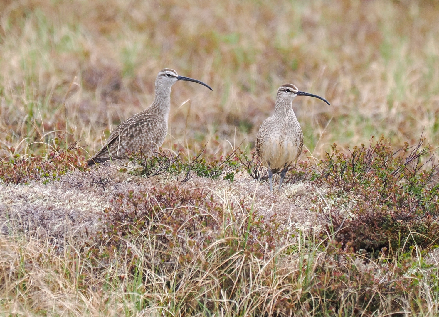
A pair of Hudsonian whimbrels on the tundra of the Seward Peninsula, June. The same species winters on the elbow of Cape Cod and along the outer beaches of Monomoy; the Center for Conservation Biology has tracked individuals covering more than 27,000 miles between the Hudson Bay Lowlands and São Luís, Brazil. Photograph by John J. King II.
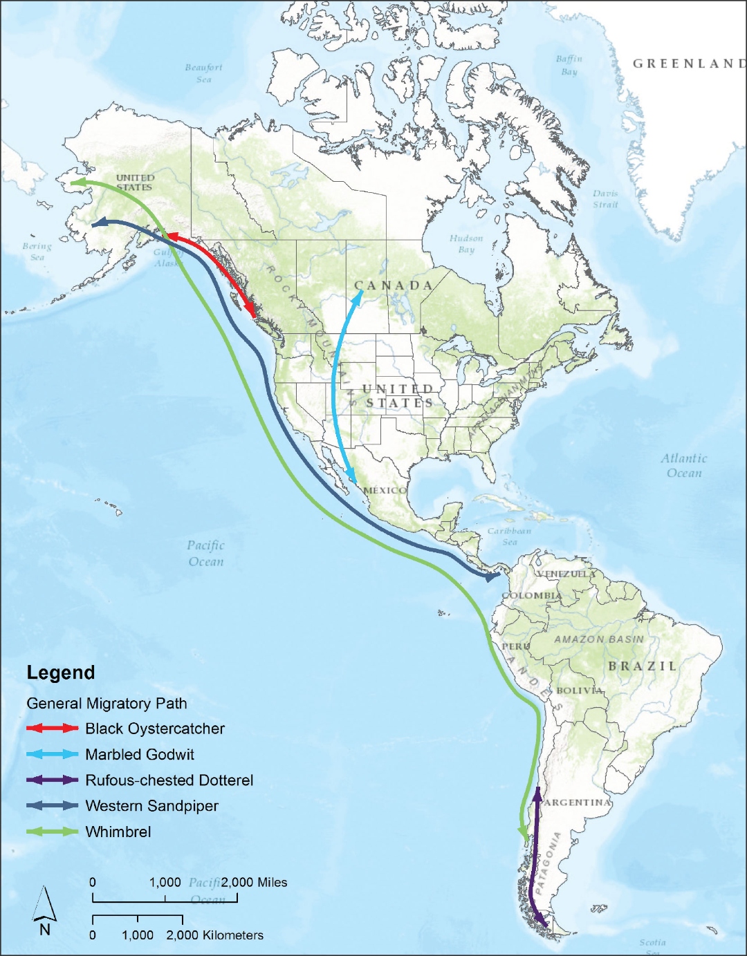
General migratory paths of five North American shorebirds. The whimbrel’s route (green) traces an arc from western Alaska to the Patagonian coast.
II. Three Eiders, and the Joke
The trip had brought us, after Nome, to Utqiaġvik — the northernmost community in the United States and, in any honest accounting of a birder's year, the address at which one settles the standing debt with the eiders. Three species in particular were on the manifest. Two of them, Pam and I had seen before, on the far side of the Atlantic. The third was the one we had flown to the top of the world for.
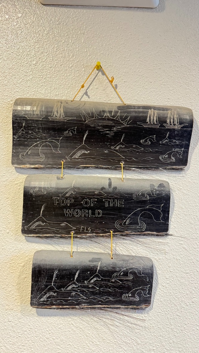
“Top of the World.” A three-panel baleen scrimshaw, signed FLS, hung as a triptych: schooners standing off the horizon, whales spouting and sounding among small islands, and the inscription across the middle panel. The piece keeps in view a nineteenth-century Arctic that was, for a period, principally an American whaleship’s view of a coast the Iñupiat had already been living on for four thousand years. Photograph by John J. King II.
The joke came first, as it almost always does. On one of our early drives out of town someone called out a Steller's eider drake at rest in a small patch of tundra wildflowers — not in the water but tucked, oddly, among the blooms beside a melting pond. Our guide, perhaps the last innocent party in the affair, slowed the van; binoculars came up; nobody wanted to flush it. The bird did not flush. The bird, in fact, did nothing at all, and we eventually drove on rather than disturb what we took to be a particularly mellow drake. We came back the next day to try for a better look. He had not moved a centimeter. He had not moved a centimeter because he was a hand-painted carving someone had nestled into the flowers, a long-running practical joke whose existence had been quietly passed along to our unsuspecting guide before he led us out to it. We stood in the muskeg and laughed at ourselves until our eyes watered, which is the response the Arctic prefers when it goes to the trouble of humbling you.
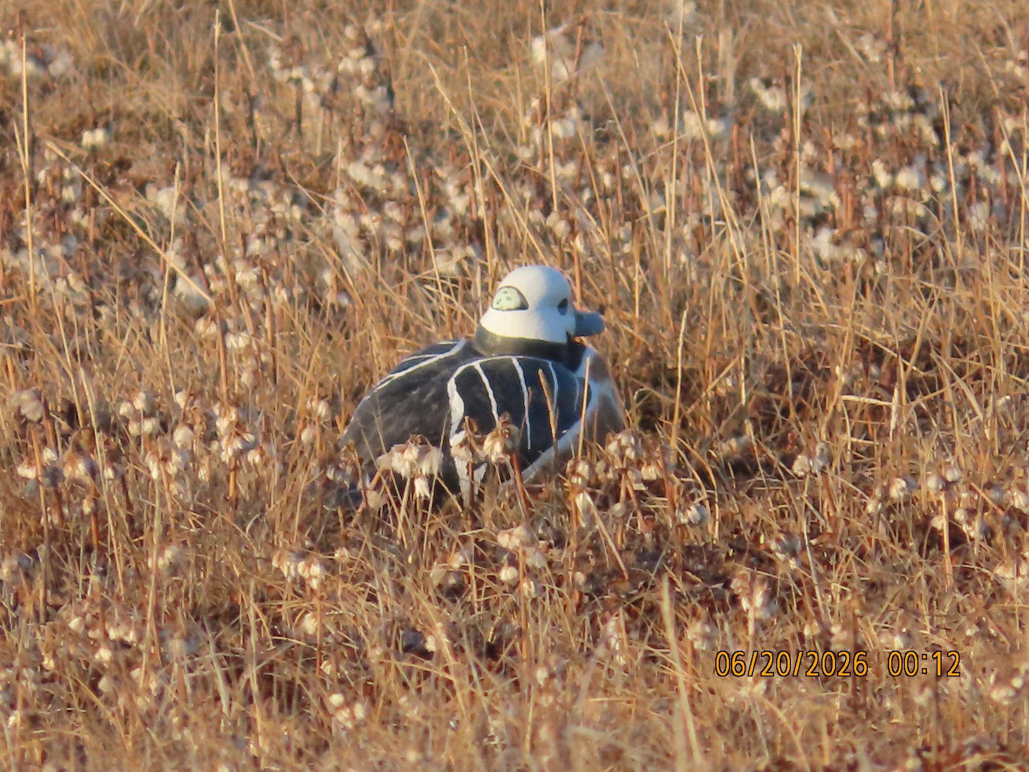
The joke itself: a hand-painted wooden Steller’s eider drake nestled in tundra wildflowers beside a melting pond, the artifact that briefly fooled our guide Benny Jacobs-Schwartz and the rest of us into thinking we had a very mellow bird on our hands. The Arctic is capable of subtler humor than it usually gets credit for. Photograph by Joan Tell.
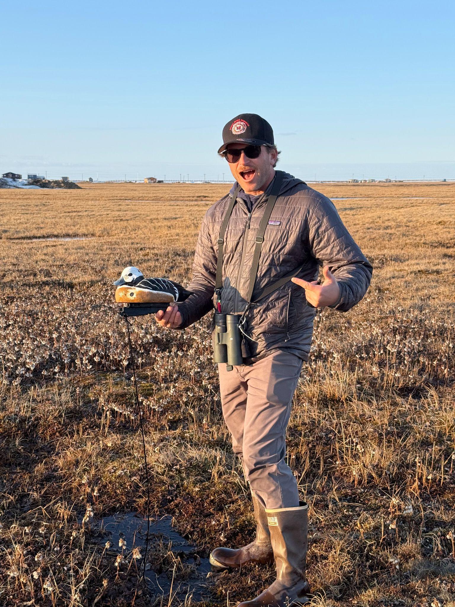
A member of our group at a scope on the open tundra outside Nome — the working posture of the enterprise that had brought us all the way north. What we found in the flowers a few minutes later would explain, retroactively, why the Iñupiat regard the whole tableau with such patient amusement. Photograph by Joan Tell.
The decoy was funny because we knew, both of us, what an actual Steller's eider should look like. Years before this trip we had stood on a stone breakwater in the town of Vardø, above the Arctic Circle on Norway's Varanger Peninsula, in February, in a wind that one cannot describe to a person who has not stood in it, watching a winter raft of Steller's eiders work the open water off the harbor in numbers that overruled the imagination. Hundreds of drakes, the chestnut breast and the small ink-dot on the white head and the cobalt scapulars all of them, riding a steel-gray sea in the polar twilight, the females tucked in among them in their understated cinnamon, the whole flock moving as a single mind across the swell. Steller's eider is critically reduced as a breeder on Alaska's North Slope and Yukon-Kuskokwim Delta — listed as threatened under the Endangered Species Act since 1997 — but the Atlantic wintering population in northern Norway is in roughly stable numbers, and to see five hundred of them at once in Varangerfjord is to feel, very briefly, that the world's accounts on this bird are not yet entirely closed.
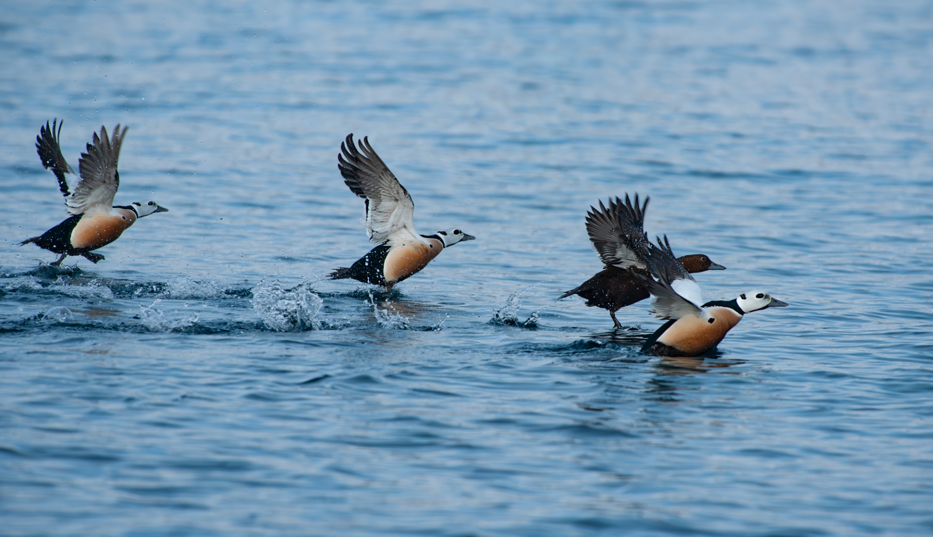
Steller’s eider drakes lifting from Varangerfjord, Kirkenes, northern Norway, in winter. The Atlantic wintering population is, for now, holding; the Alaska breeder was listed as threatened in 1997. Photograph by John J. King II.
The King eider had been on the same coast, in the same winter. There are birds one sees in field guides and assumes the illustrator has been carried away, and then there are birds one meets in life and realizes the illustrator was practicing restraint. The drake King eider is the latter. The orange knob at the base of the bill, the pearl-blue crown shading to a paler nape, the sage-green wash on the cheek, the small black sail on his back — all of it on a barrel-chested bird with a salmon-pink breast, riding the same dark water as the Steller's flock with the unhurried buoyancy of a creature engineered, by long deep-water diving, to need nothing from the surface but air. King eiders breed across the high Arctic from Banks Island to Severnaya Zemlya and winter at sea wherever the ice still allows, which means that the drakes and hens we watched flying low over the Alaska coast that week had likely been hatched somewhere on a Russian island whose name the rest of the world does not bother to learn. He had not consulted any map I would have recognized as one. He had simply moved with the season, the way the eiders have moved with their seasons for the long arc of evolutionary time that has shaped them, and he gave the small breakwater-bound humans the brief courtesy of allowing himself to be looked at.
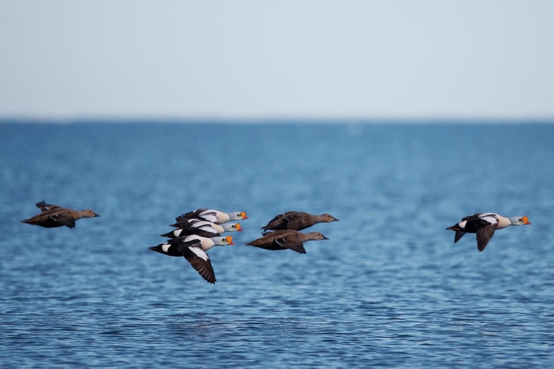
A tight flock of King eiders — the drakes with their orange bill-knobs, pearl-blue crowns, sage-green cheeks and small black sails; the hens in the deep cinnamon browns nature reserves for the half of any species actually required to keep it going — low over the water off the Alaska coast, all of them moving with the season the way the eiders have always moved with theirs. Photograph by Lina Grube.
The laughter at the Nome decoy, then, had been the laughter of people who had been mocked specifically. We knew the bird. The Arctic, as it happened, was about to reward us. Within a mile of the joke, scanning a shallow melting tundra pond a mile or two farther down the road, one of our group found the real thing: a genuine pair of Steller's eiders, the drake's chestnut breast and pale, black-spotted head almost cartoonishly handsome against the gray water, the hen alongside him in the warm earth tones that nature reserves for the half of any species actually required to keep it going. It is one thing to be fooled by a decoy. It is another thing to be rewarded, the same week, with the bird the decoy had been mocking us about. The Arctic, having had its fun, was now prepared to give.
The spectacled eiders came a day later, and they came in company. We found the pair on a small Utqiaġvik pond still half-rimmed in ice, swimming the lazy perimeter of the melt in the middle of a substantial gathering of Pacific loons in full breeding plumage — the loons' velvet-black heads and silvered necks catching the low Arctic light, the drake eider low in the water with that absurd, painted-on white spectacle around each eye and the smudged sea-green nape that no field guide has ever quite done justice, the hen beside him warm cinnamon and finely barred, as if someone had taken a fine pen to her. They gave us more than an hour. They swam, they fed, they ignored us entirely, they tracked the receding edge of the ice around the pond as if it were a slow clock. A spectacled eider is the kind of bird most birders chase for whole careers and never see — it breeds across a narrow ribbon of the Y-K Delta and the North Slope, then disappears each winter to a single offshore polynya in the central Bering Sea, the kind of biographical detail that would be implausible in a novel and is merely true in a duck. To watch a pair of them at leisure in the company of loons, on a pond no one will ever name on a map you can buy, is to be paid back in full for every wasted Nome afternoon, and then some.
Inset
Spectacled Eider (Somateria fischeri)
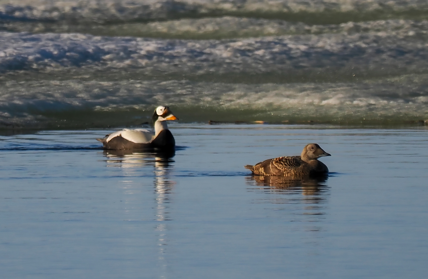
Spectacled eider pair on an ice-rimmed Utqiaġvik tundra pond, June. The drake at left in breeding plumage, with the pale sea-green nape and the white spectacles bordered in black; the hen at right in finely barred cinnamon. Photograph by John J. King II.
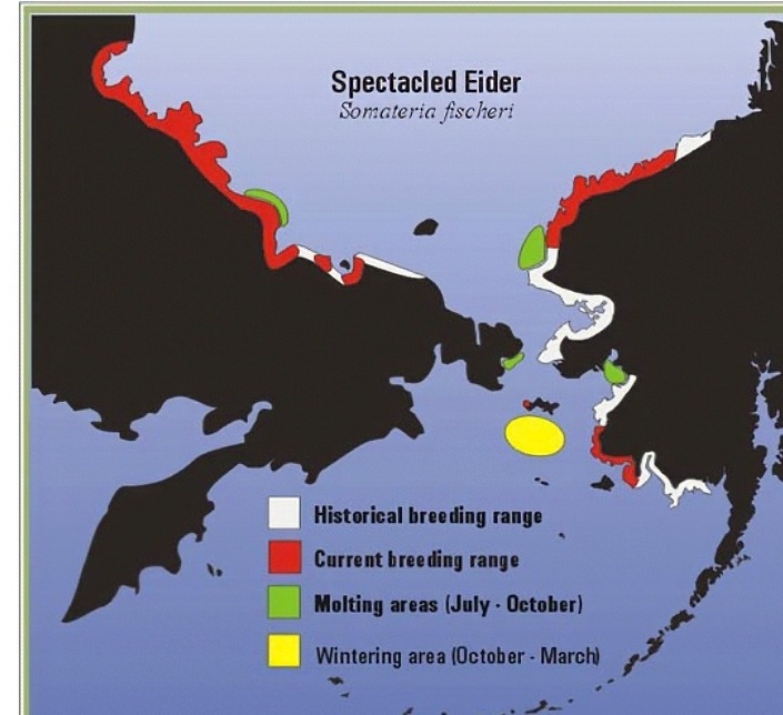
Spectacled eider range. Historical breeding range in white; current breeding range in red. The Yukon-Kuskokwim Delta supported roughly fifty thousand nesting pairs in the 1960s and carries perhaps six thousand today — a collapse of nearly ninety percent in a single human lifetime. Molting areas (green) and the central Bering Sea wintering area (yellow) hold the entire world population each winter. Map: U.S. Fish and Wildlife Service.
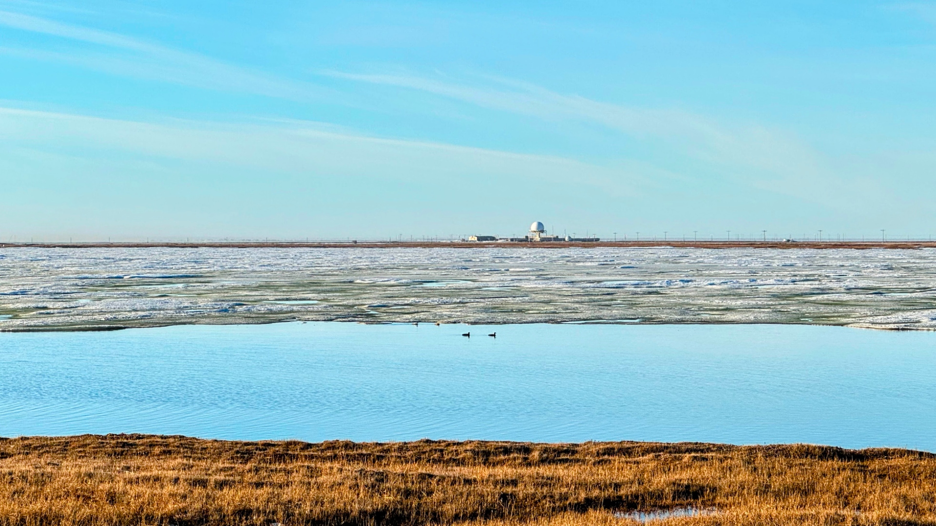
The loon pond outside Utqiaġvik in mid-June — the spectacled eider pair and two Pacific loons visible on the open water at center, the receding sea ice broken into pans behind them, the DEW-line radome and the low buildings of the old NARL station on the horizon. The pond itself is unnamed on any map you can buy; it holds, on this afternoon, the entire narrow business of a species that has lost most of itself within living memory. Photograph by John J. King II.
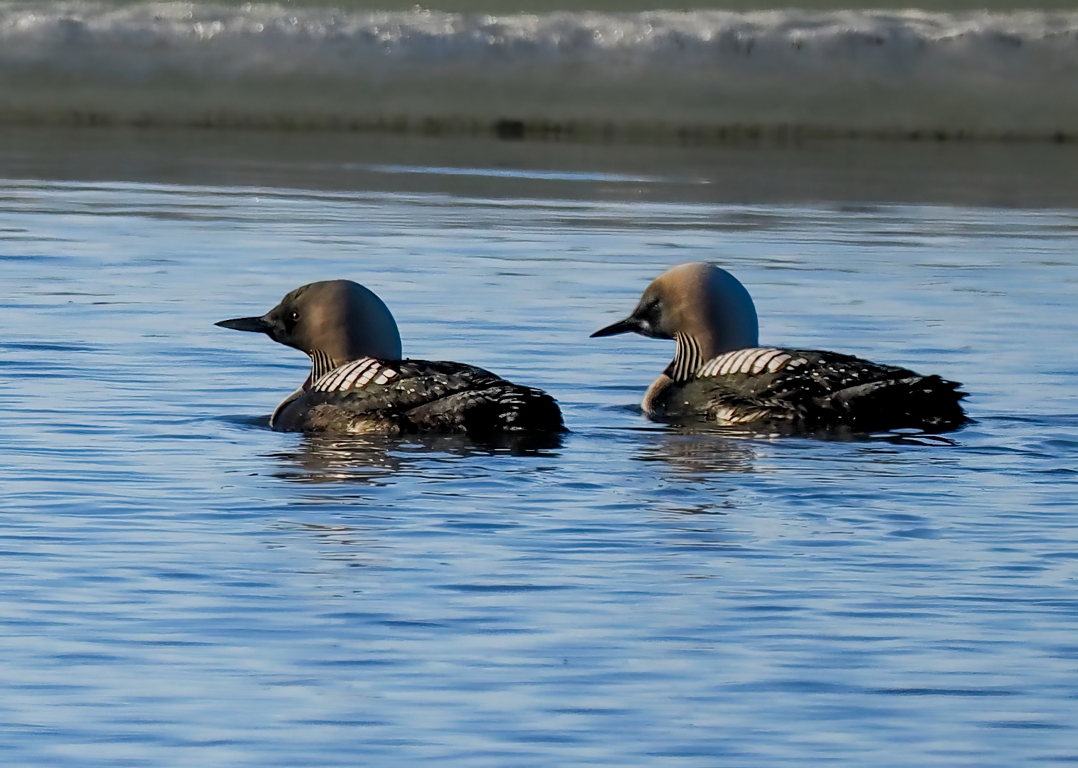
The company the eiders kept: a pair of Pacific loons (Gavia pacifica) in full breeding plumage on the same Utqiaġvik pond — the velvet-gray head, the silvered nape, the striped black-and-white throat necklace that no field guide has ever quite done justice. For the hour we watched, the loons and the eiders tracked the receding edge of the ice around the pond together, ignoring us entirely. Photograph by John J. King II.
The pair on the loon pond outside Utqiaġvik — the one described on the facing page — were a small living remnant of a population that has lost most of itself within living memory. The spectacled eider is a large sea duck, twenty to twenty-two inches at rest on the water, and the drake in spring is a bird that looks, on first sighting, like a sober green-headed duck onto whom someone has painted, in unembarrassed white, a pair of perfect spectacles bordered in black. The hen is the warm barred brown the species reserves for the half of itself that has actual work to do. Drakes leave the breeding grounds within a week or two of the eggs being laid, heading out to molt in Ledyard Bay or eastern Norton Sound, and the entire world population then converges, by November, on a few openings in the sea ice in the central Bering Sea between St. Lawrence and St. Matthew — a winter address so improbable it was not even located until 1995, when satellite telemetry finally tracked the birds to it.1
The world population is now estimated at around 370,000 birds, most of them in Russia; the Yukon-Kuskokwim Delta, which carried roughly fifty thousand pairs in the 1960s, carries perhaps six thousand today — the kind of collapse that, in any species we cared about the way we say we care about ducks, would already have a name.2 The bird was listed as threatened under the Endangered Species Act in 1993, and the suspected drivers read like a small encyclopedia of late-modern environmental harm: lead pellets ingested incidentally at feeding sites, illegal harvest in the hundreds of birds a year, nest predation by foxes and ravens and gulls whose populations are subsidized by the food and shelter of human settlement, and, hardest of all to address, the warming of the Bering Sea itself and the reshuffling of the bottom-dwelling mollusks and crustaceans on which the eider depends for eight to ten months of every year.3 On the breeding grounds the USFWS guidance to anyone who blunders into a nesting pond is unambiguous and worth repeating: do not approach, do not flush the female, retreat the way you came — an approach on foot leaves a scent line that an arctic fox will follow with the patient arithmetic of an animal that has been doing this for as long as there have been ducks.4 A bird most birders chase for whole careers without seeing, and that the Bering Sea may not, on present terms, continue to produce.
Photograph © John King.
III. The Captain's House, and a Bering Beyond Borders
The Iñupiat had been watching us watch the birds. This was the open secret of the trip, the thing one figures out, with delayed embarrassment, only after the fact: that the people whose town we were birding from had every reason to be amused by the spectacle, and were generous enough not to show it. They had been on this coast for four thousand years. We had been there a week. Our scopes were pointed at ducks. Theirs were pointed at something larger.
Pam noticed it before I did — the small politeness of a village that had absorbed birders before and would absorb them again, extending to the visiting party the ordinary courtesy one extends to guests who have not yet understood the house they are in. It is a form of patience one has to have earned, over some generations, to give.
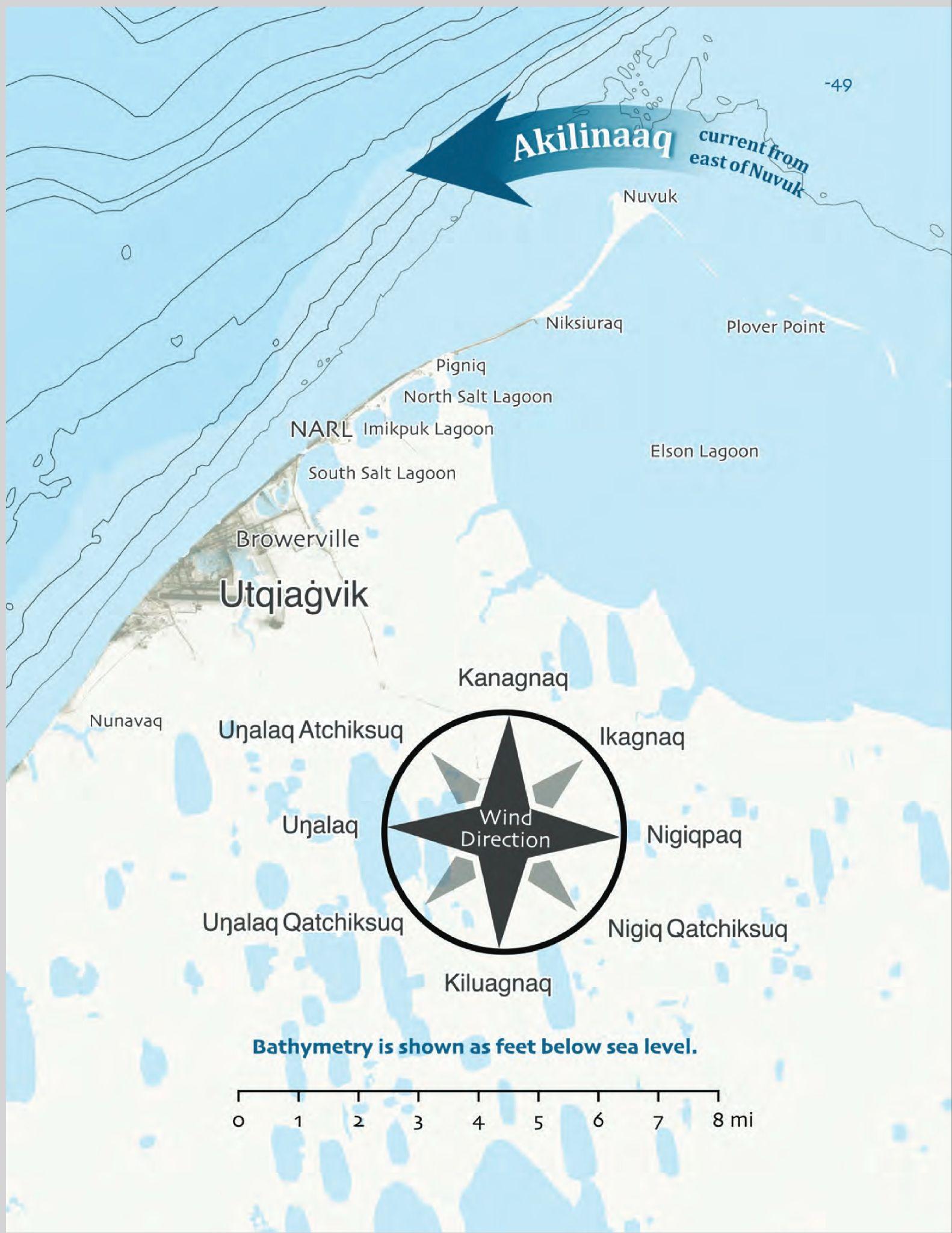
Prevailing winds and sea-floor bathymetry off Utqiaġvik and Point Barrow. The map is a working document for whaling crews and ice observers — it shows the wind that opens and closes the leads, and the shelf on which the bowheads have always fed. Map courtesy of Alaska Arctic Observatory & Knowledge Hub.
Utqiaġvik — Barrow, until the town voted in 2016 to take its own name back — is the northernmost community in the United States and the cultural capital of the Iñupiat of Alaska's North Slope. The name means, in translation, "a place where snowy owls are hunted," a sentence the colonial map declined to render and that, once you have read it, is impossible to unread. For at least 4,000 years, life on this coast has been organized around the bowhead whale. As the Alaska Eskimo Whaling Commission puts it, from Gambell to Kaktovik "the bowhead whale has been our central food resource and the center of our culture for millennia" (International Whaling Commission). Eighty-four percent of households in the whaling villages still eat bowhead, distributed through kinship and ceremonial networks of a complexity that would defeat any modern supply chain (ArcticToday).
What the outsider has to understand — what Pam and I, as lifelong conservationists who revere whales above almost any other animal on Earth, have come slowly and not without embarrassment to understand — is that Iñupiat whaling is not the same act as commercial whaling and has never been. The word, in English, is the same. The act is not. It is a relationship, conducted with the seriousness one brings to a marriage or a debt of honor. In Iñupiaq cosmology the bowhead is a sentient being with agency, and it gives itself to a hunter and his crew not because they have outwitted it but because they have, over the preceding year, earned it — by their generosity, their ritual care, the quiet conduct of their households (Smithsonian / Crowell; National Park Service). The whale, it is said, sees the umialik (the whaling captain) and his wife from far off and judges them; the captain's wife is spiritually linked to the whale, and her conduct — her quiet, her hospitality, her sharing — is held to determine whether the whale will choose the boat. A landed whale is offered a drink of fresh water before butchering, so that its soul may travel home refreshed and report kindly on its treatment, ensuring that other whales will come (Hakai Magazine). The festival drums, qilaun, are stretched over the whale's own organ lining, so that the animal continues, after a fashion, to sing through the people who took it (Smith College Climate in Arts and History). None of this is metaphor. The Iñupiat themselves put it more simply than any anthropologist has managed: one cannot live without the other.
The culmination is Nalukataq, the spring whaling festival held in late June across the North Slope villages — Utqiaġvik, Point Hope, Wainwright, Nuiqsut, Kaktovik — timed against the very solstice we ourselves traveled through (KNBA). The successful captains do not keep the whale. They give it away. Quaq (frozen raw meat), maktak (skin and blubber, which tastes, in case you are wondering, of cold hazelnut and the sea), mikigaq (fermented meat), tongue, flukes, heart — all distributed in formal portions to every family who comes, elders and the sick and those who cannot hunt fed first, visitors from distant villages sent home with packages so heavy they have to be shared on the plane. The blanket toss that gives the festival its name was, in older understanding, a way for the whales themselves to look up and see the people and decide whether to give themselves again the following year. Prestige in this culture does not accrue to the captain who takes the most. It accrues to the captain who gives the most away. One pauses, briefly, to imagine the American economy under such a rule.
The relationship has had to survive more than weather. European and American commercial whalers nearly exterminated the Bering Sea bowhead in the nineteenth century, slaughtering for baleen and oil at a scale and stupidity that beggar description, and then in 1977 the International Whaling Commission — reacting to a flawed population estimate and a more general atmosphere of well-meaning panic — abruptly banned Iñupiat subsistence hunting. The hunters learned of the ban after the fact, which is to say in the manner of all things done to Indigenous people by international bodies (Cultural Survival Quarterly). The villages organized within weeks, founded the Alaska Eskimo Whaling Commission, lobbied Congress, and won a quota in 1978. Iñupiat elders ultimately taught Western scientists how to count whales beneath the ice — a sentence one should pause on — and modern surveys now place the Bering-Chukchi-Beaufort population at roughly 20,000 animals, a recovery story almost no one tells. Crawford Patkotak, an Iñupiaq whaling captain from Utqiaġvik, has said that the 1977 moratorium "turned Iñupiat culture on its head" — a useful reminder that the threat from outside has often been not malice but ignorance, which in moral terms is sometimes the harder thing to forgive.
Inset
What a Captain's Flag Is, and What It Does
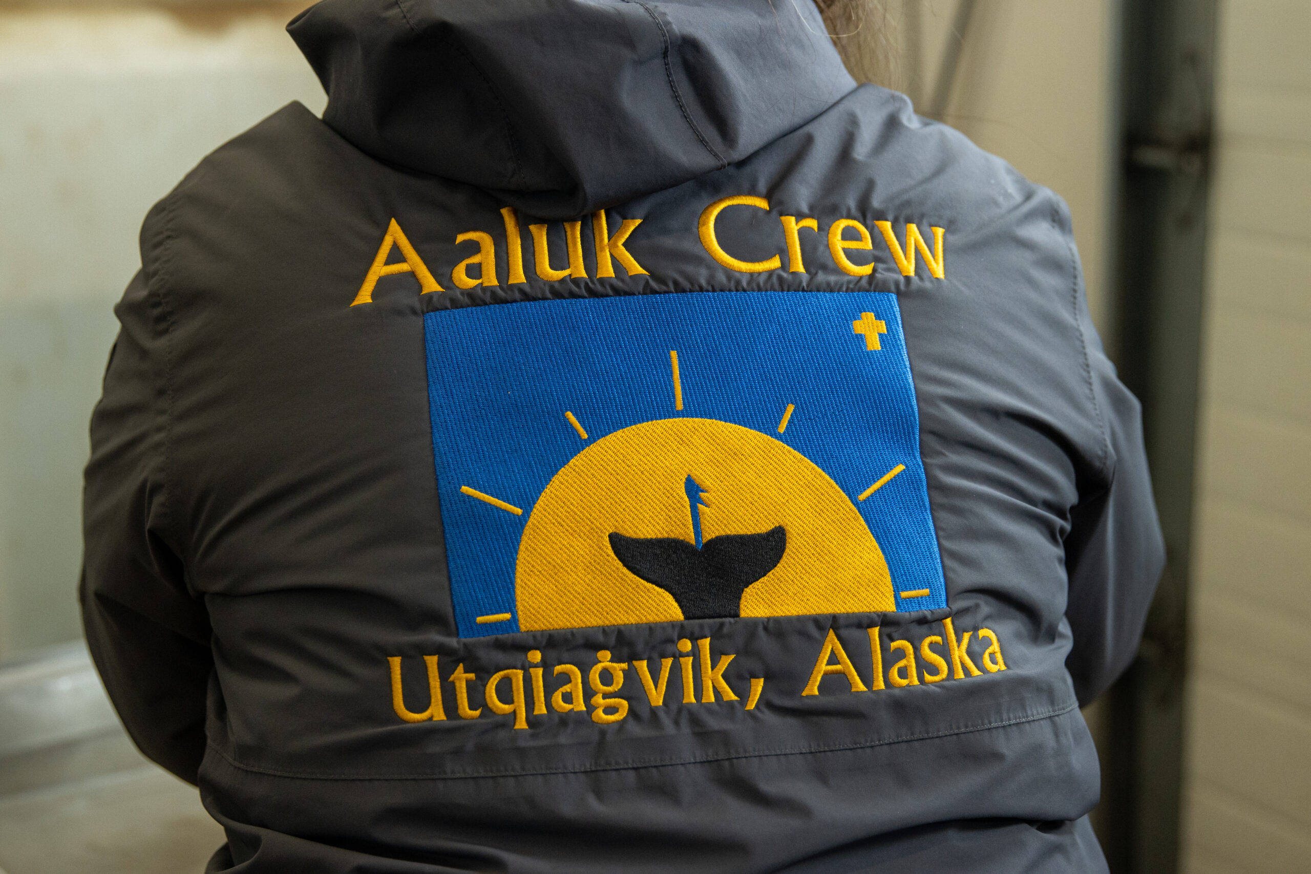
The flag of the Aaluk Crew, Utqiaġvik. Designed by the family of co-captains Bernadette and Quincy Adams, the insignia carries a black bowhead fluke rising from a golden sun on a blue field, with the harpoon shaft still standing in the whale and a small cross in the upper right — a single image of strike, sustenance, and reciprocity. Photograph by Valerie Lake / Alaska Public Media.
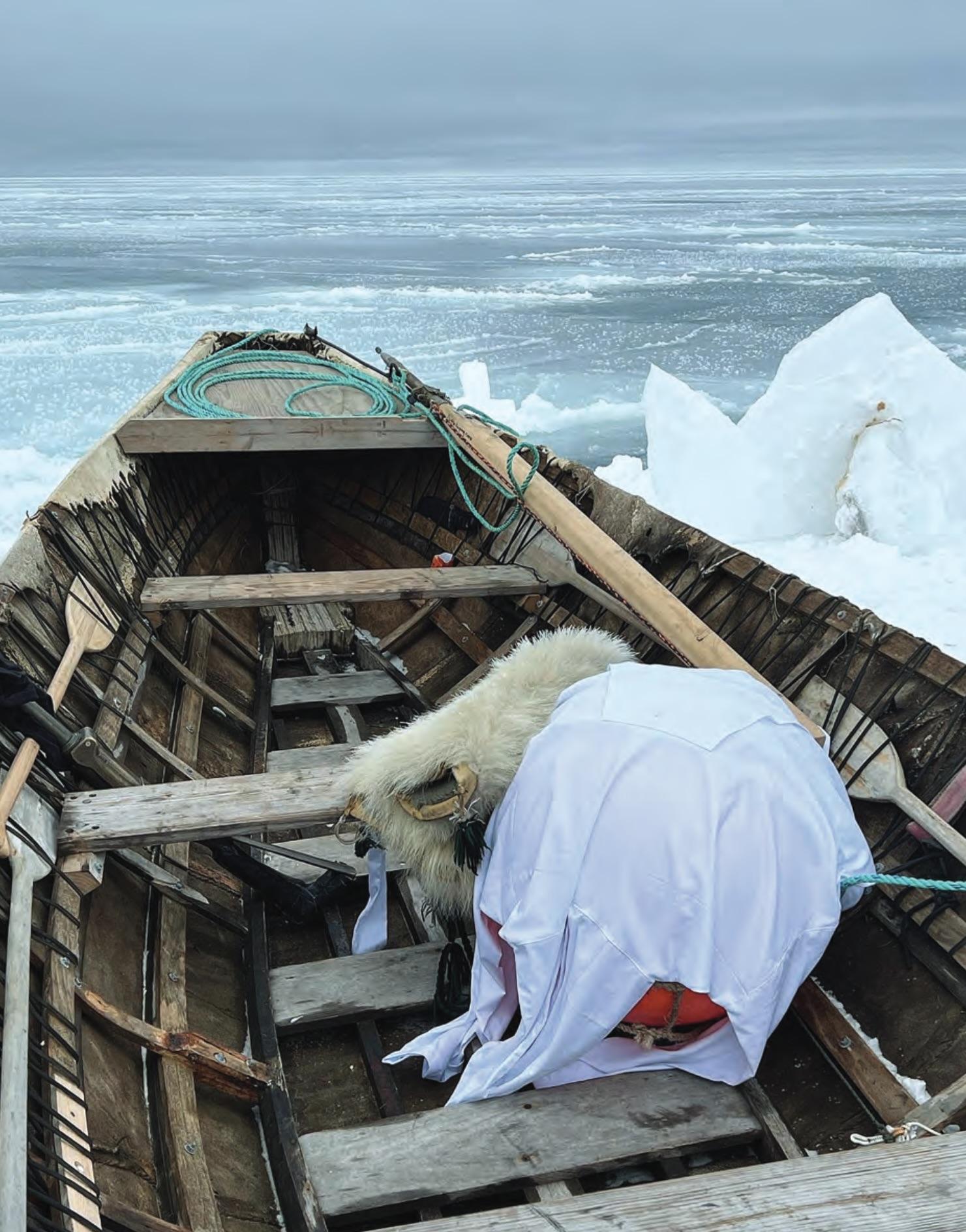
A sealskin umiak drawn up at the edge of the shorefast ice, its crew flag raised on a slim pole beside it — the working posture of a whaling camp waiting for the bowheads to move through the lead. The flag on the pole and the flag on the roof are the same flag, doing different halves of the same job. Photograph courtesy of Alaska Arctic Observatory & Knowledge Hub.
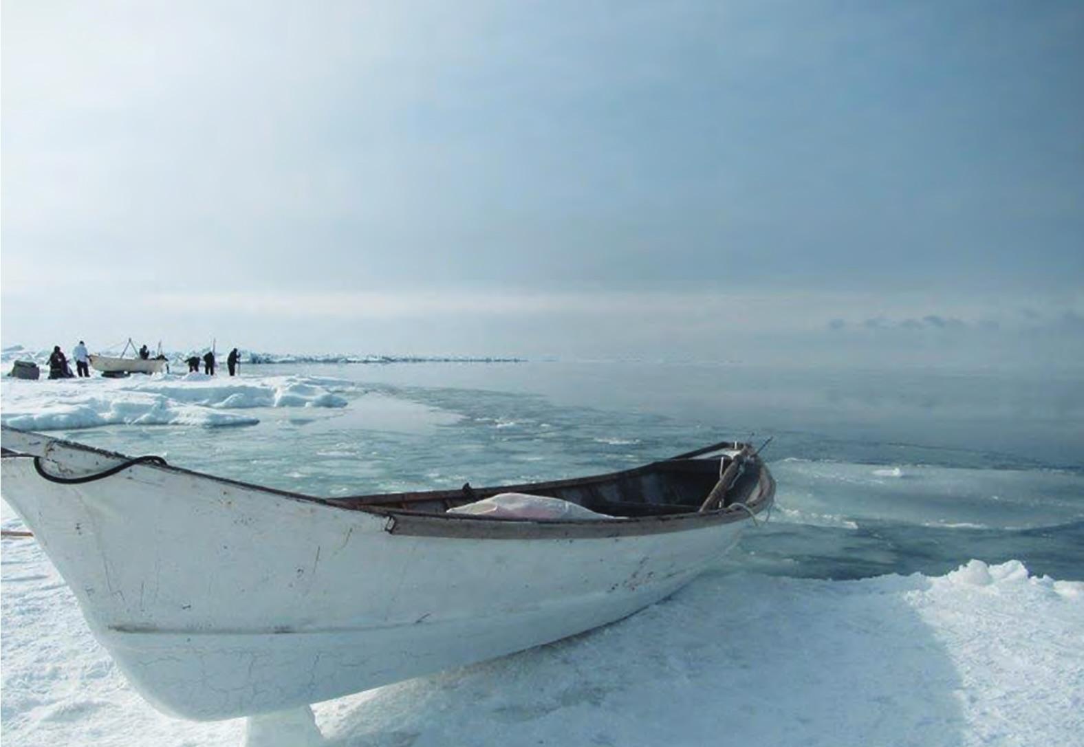
The same craft at the working edge itself: sealskin over a wooden frame, silent enough to slip up on a bowhead the way the bowhead is said to prefer being approached. This is the boat the shore-fast ice has always been the working platform for; both are, now, on a shortening lease. Photograph courtesy of Alaska Arctic Observatory & Knowledge Hub.
In Utqiaġvik and the other North Slope villages, every registered whaling crew — there are between twenty-five and forty-five in Utqiaġvik in any given season — flies a distinctive flag designed by or for the umialik, the whaling captain, and his family.5 The flag is not decorative. It does specific work at three moments.
On the ice, the moment of the strike. The flag is hoisted on the tallest piece of ice over a landed bowhead to signal successful hunt — come help, and to mark the harvest site for the boats and snowmachines converging from town.6
On the captain's house, the day of the feast. A smaller version of the same flag is raised on the roof to announce whose crew landed the whale and to summon the community to nigipkaq, the day-after feast where half the meat and maktak is shared out. When the food is gone, the captain pulls the flag down — the public sign that the obligation has been honored.7
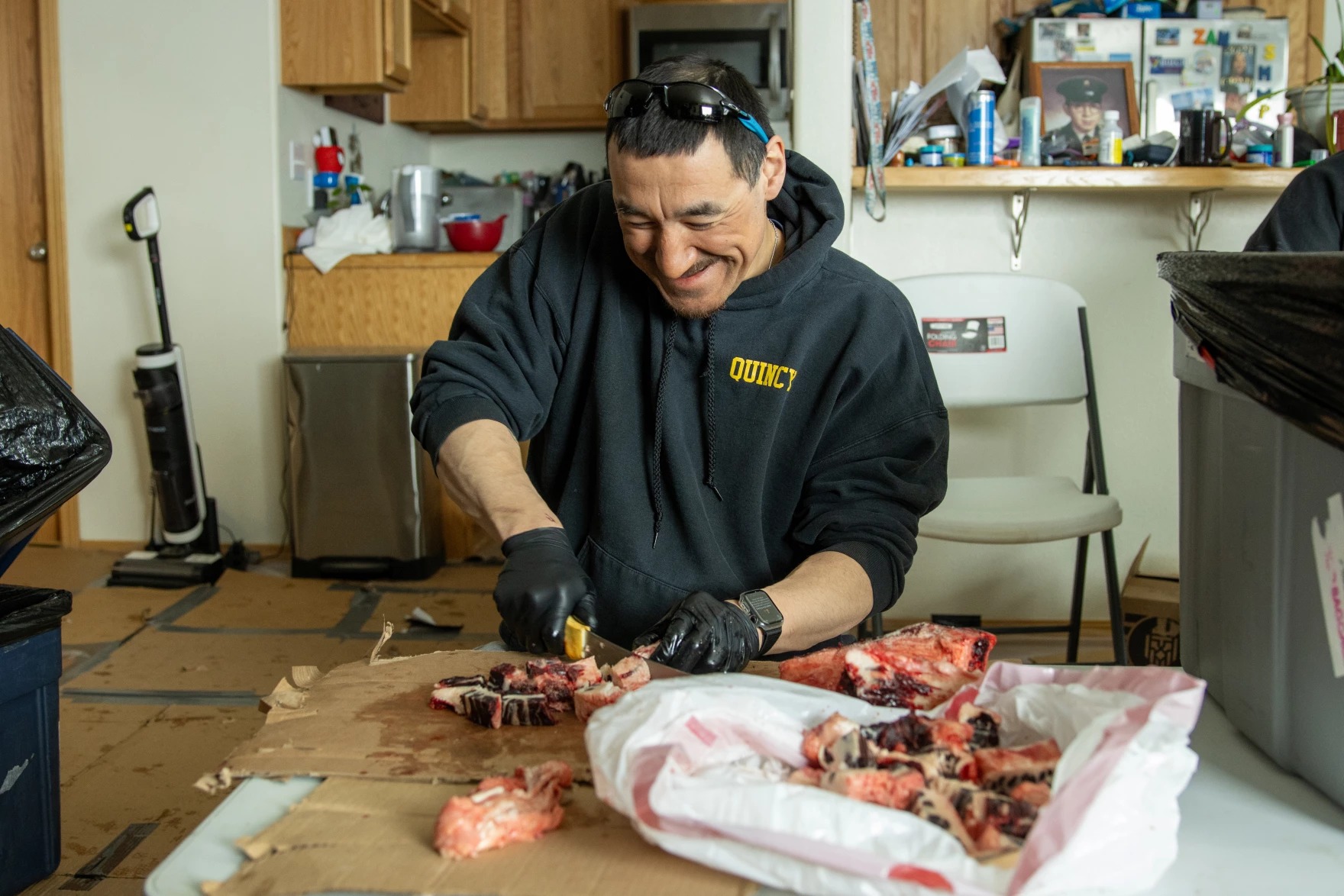
Quincy Adams, co-captain of the Aaluk Crew, butchering bowhead in his kitchen the morning after his crew landed the first whale of the 2024 spring season. The flag commits the captain to the labor; the labor sustains the community. Photograph by Valerie Lake / Alaska Public Media.
At Nalukataq. The crews' flags are raised at noon over the qalgi, the festival ground, to open the spring blanket-toss festival, where each umialik's prowess is formally recognized by the community.8
The flag is therefore both a boast and a bond. It announces that this captain and his wife are able to provide, and it simultaneously commits them to give the whale away. As the International Whaling Commission’s Alaska delegation puts it, the captain is “ever-aware of [his] responsibility… to respect and honor the whales that give themselves to our communities.”9
Photographs courtesy of Valerie Lake / Alaska Public Media, 2024.
Years before this trip, on the Russian side of the same sea, Pam and I were given the encounter that, in retrospect, made everything we would later see in Utqiaġvik legible to us. The village was Lorino, on the Chukchi coast, the easternmost edge of Russia and a place that on most American maps does not appear at all. The Bering Strait between us and Alaska was, that summer, a perfectly ordinary stretch of cold water. The people on either side of it — Iñupiat in Utqiaġvik, Chukchi in Lorino, Yupik in both — had been crossing it freely for several thousand years before any cartographer decided to draw a line through it. They are the same coastal people, divided by an arbitrary mid-ocean longitude, conducting the same relationship with the same whales.
A gray whale had been brought in that morning. By the time we arrived on the beach — gravel, the color of wet pewter, the air smelling of cold salt and the iron of cut meat — the work was already underway and would continue, with the unhurried efficiency of an old and unchanging procedure, for most of the day. The whale lay at the tide line, enormous, dark, opened along the flank with long flensing cuts. Men moved along its length with knives whose shape one understood, on sight, to be the consequence of several thousand years of careful refinement. Older women worked the strips of meat that came off the carcass, sorting them into piles by part and by intended recipient. Children — and this was the detail Pam returned to, afterward, more than any other — moved through the scene with strips of fresh blubber in their hands as if the strips were licorice, eating as they went, included in the work in the casual way that children are included in all real work in places that have not yet forgotten how to do it.
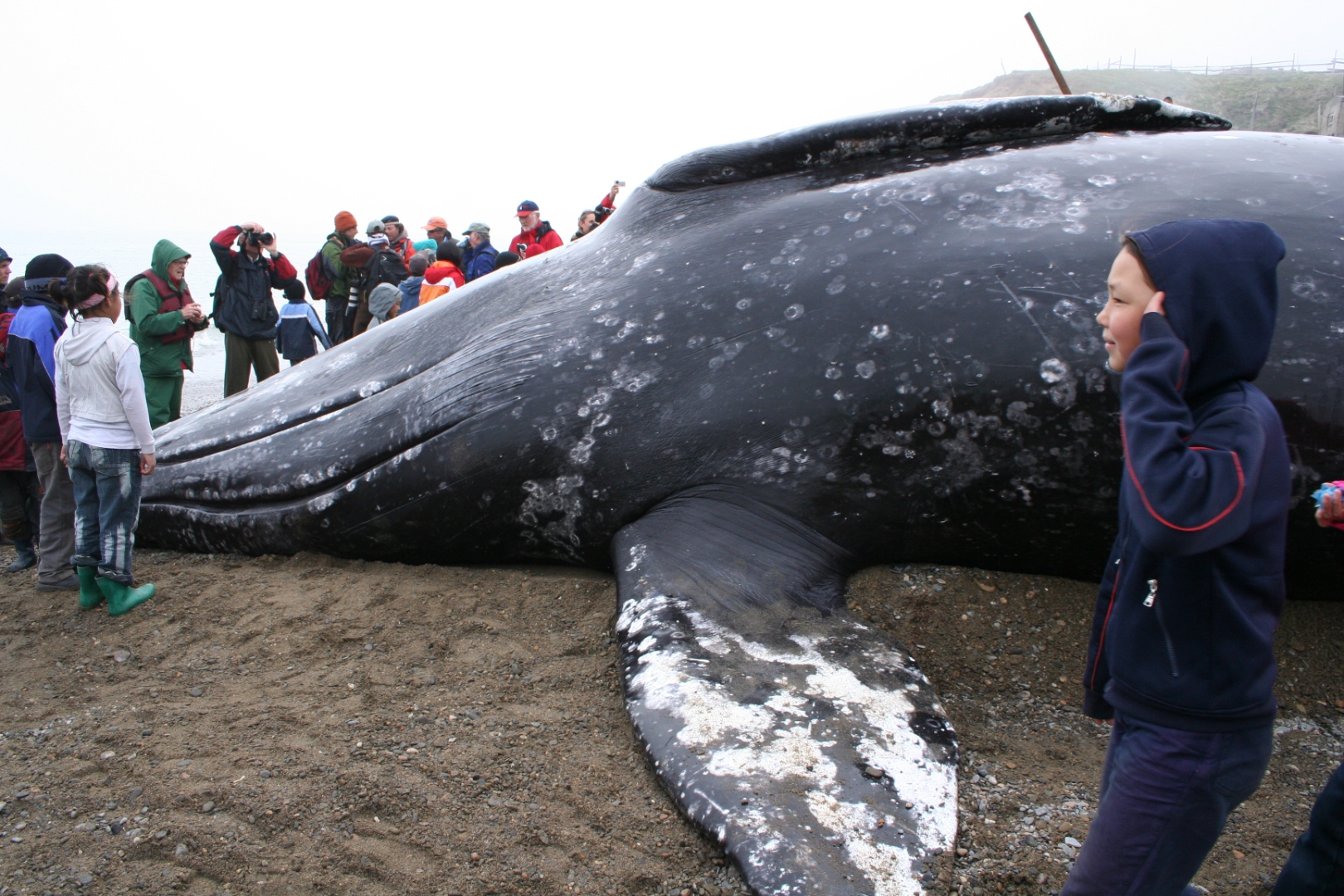
The landed gray whale on the gravel beach at Lorino, Chukotka, the morning after the hunt, June 2008. The barnacle scars are white against the dark hide; the shaft of the darting-gun still stands in the flank. Photograph by Pam King.
Before the first knife touched the hide, the village opened the day with a ceremony of thanks. A priestess and a young acolyte, both in the bright floral parkas of the Chukchi coast, moved down the beach past the crowd to the whale and, at the shoulder, laid out simple offerings on the animal’s flank — bread, a small dish of what looked like tea leaves, a pinch of tobacco — speaking, in the old language, a short thanks to the whale for having consented. It was the entire ethic of the day condensed into thirty seconds of quiet ritual: the animal was not a resource, it was a guest who had accepted an invitation, and the community’s first obligation was to say so out loud before the flensing began.
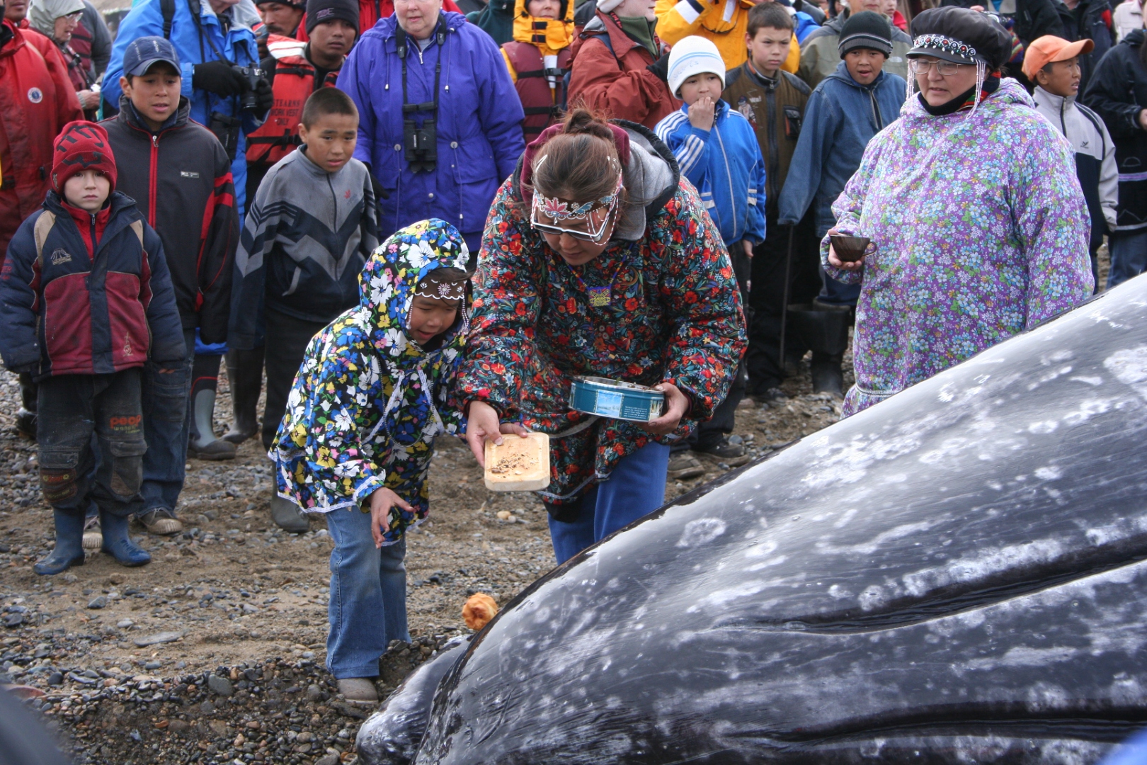
The priestess and her young acolyte laying bread and tea on the whale’s flank at the start of the day, before the flensing begins — the village’s formal thanks to the animal for having consented. Photograph by Pam King.
Later in the afternoon, after the work had settled into its rhythm and the meat had begun to move, the young people gave the day back its other half. A girl in a ceremonial black-and-white parka, her face powdered pale, knelt in the sand and lifted her white-gloved hands to the low sun in a slow gesture of invocation, watched by other children in the fur-trimmed regalia their mothers had sewn for the occasion. It was the celebration the flensing had been earning all morning: not commerce, not sport, but a village doing, in the open, the thing it was made to do.
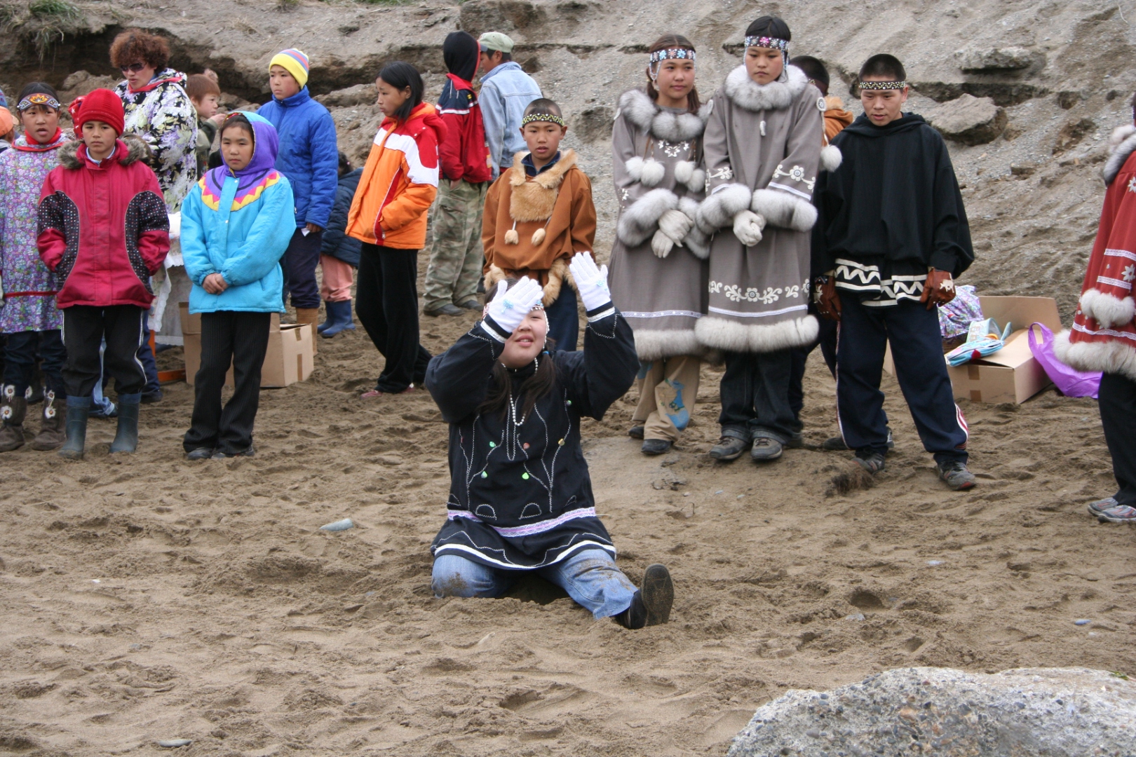
A young dancer in ceremonial parka lifts her hands to the low sun during the afternoon’s celebration, Lorino, June 2008. Photograph by Pam King.
We had arrived as the conservationists we still are, instinctively braced against the sight, prepared to feel the small clean pang of one's principles being honored. What we saw instead was a community fed. The elders were served first, in formal portions, by name. The widows received their share without having to ask. The men who had taken the whale received theirs last, which is the way the system has always worked and which one has to be standing on the gravel to fully understand. The carcass was reduced over the course of the afternoon with a thoroughness that left, by evening, almost nothing — the meat divided, the maktak set aside in the lacquered black sheets the Chukchi prize as the Iñupiat do, the bones eventually given back to the sea so that the whale's spirit, in the village's understanding, might travel home and report kindly on its treatment. There was no commerce in any of it. There was no cruelty. There was hunger satisfied and a thousand-year-old contract honored, and a celebratory atmosphere that one recognizes, when one finally sees it, as the natural emotional weather of a community doing exactly what it was made to do.
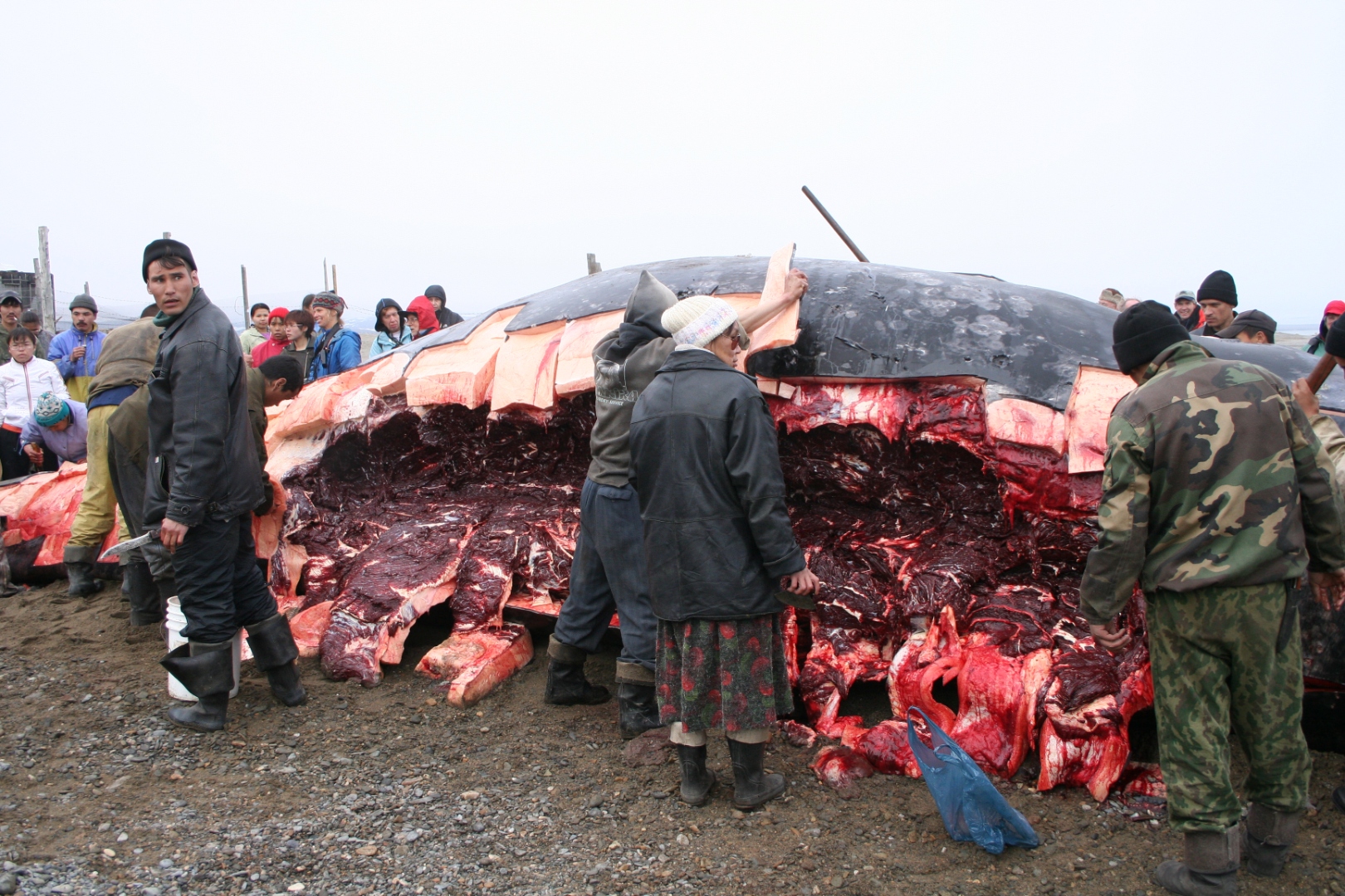
The whale opened along the flank in mid-afternoon: the blubber peeled back in pale pink sheets, the meat exposed in dark red bands, the village working the carcass together. By evening the beach was clear. Photograph by Pam King.
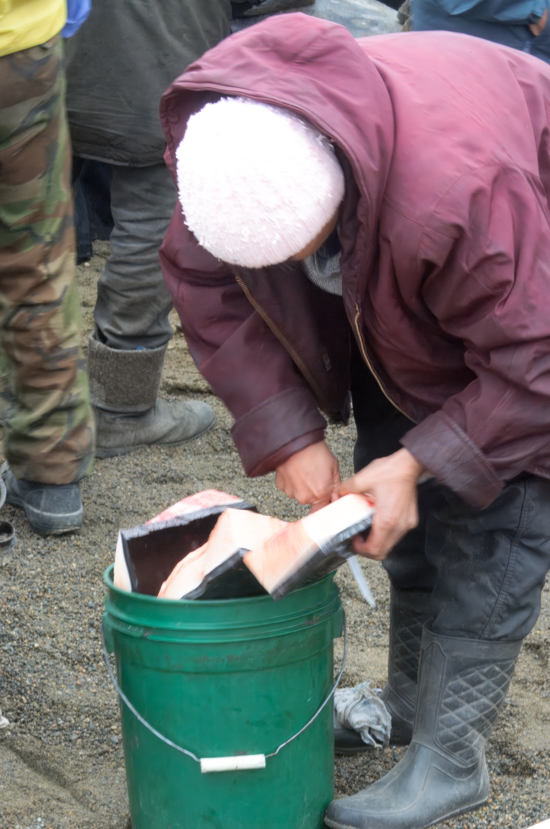
A family’s share of the whale, packed into a green five-gallon bucket. Every household on the coast went home with meat and maktak; leftover portions were sent to the neighboring village or stored in the community’s permafrost cellars for winter. Photograph by Pam King.
Pam, who as I have said has the better field eye, said something on the drive back to our boat that I have been turning over for the better part of two decades. She said: We were wrong about something. Not about whales. About people. The conservation movement we had spent our lives inside had taught us, very effectively, to defend whales from commerce. It had not taught us, at all, to recognize the difference between commerce and culture. Lorino taught us that. We carried the recognition north, across an arbitrary border, to Utqiaġvik. It is the right luggage for this country. The Bering is not two coasts. It is one ocean, with one coastal people on either side, doing the same old work.
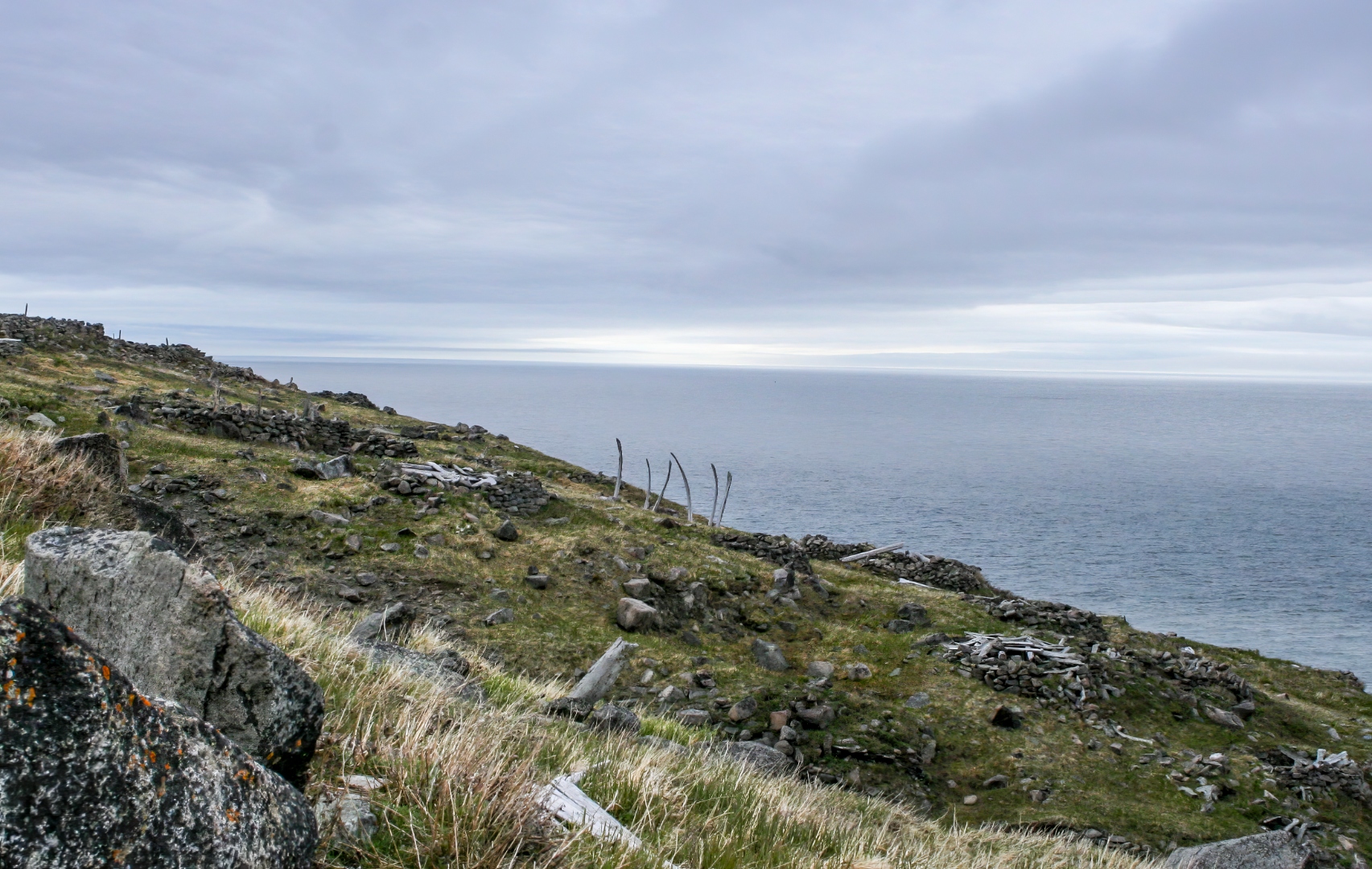
A whalebone graveyard on a Chukchi bluff above the Bering Strait, ribs still standing in the ground, Little Diomede visible on the horizon. The same coastal people live within sight of each other, on either side of a line no whale has ever consulted. Photograph by Pam King.
Pam and I are not an umialik and his wife. We have not stood on the ice, we have not landed a whale, we will never be judged by one. But a conservation life shared between two people, over half a century, on two coasts of the same ocean, has felt to us — and I write this with the caution the sentence requires — like a distant cousin of the reciprocity the coast has been describing all along. The whale sees the household. The household is the unit. That much, at least, we recognized.
The other defining intrusion came in 1971, when President Nixon signed the Alaska Native Claims Settlement Act. We had known none of this on the plane north. We were learning it, as most Americans of a certain age learn such things, in the wrong sequence — after the country had already been kind enough to let us walk on it. ANCSA extinguished aboriginal title across the state in exchange for $962.5 million and 44 million acres conveyed not to tribes — which is the form of organization Native peoples themselves had used for millennia — but to twelve regional and more than two hundred village for-profit corporations, an arrangement that converted ancient relationships with land into something that could be audited (ANCSA Resource Center). The North Slope was the only region to oppose the bill, recognizing it for what it largely was: a corporate workaround engineered to clear title for the Trans-Alaska Pipeline. Iñupiaq elder Oliver Leavitt later recalled congressional attitudes with a directness no diplomat could improve on: "To them, you were a f—king savage" (Alaska Public Media). After passage the Iñupiat did what Iñupiat have always done, which is to organize: they fought to form the North Slope Borough, which uses oil-infrastructure taxes to fund the schools, the clinics, and the Iñupiat Heritage Center — funding, in other words, the recovery of the culture out of the very revenues that the act was designed to enable. Language has been the deepest wound, as language always is. By 2007 only 13 percent of the Iñupiaq population spoke the language fluently; that figure climbed to 22 percent by 2021, driven by immersion schools, family-based programs, and projects like MIT-trained linguist Annauk Olin's effort to build digital tools for Iñupiaq learners (MIT News). One should be careful not to mistake survival for victory. The Iñupiat have not won. They have, against considerable odds, continued.
Inset
How the Coast Tells Itself: Four Objects from a Bering Vernacular
The other thing one learns in Utqiaġvik, sitting for a while in the Iñupiat Heritage Center or wandering the modest galleries and gift rooms that punctuate a town not otherwise given to tourism, is that the coast has been narrating itself in objects for four thousand years, and that the narrative is still going. What the outsider takes for craft is, at this latitude, a working literature. The bowhead is drawn, carved, etched, stitched, and reprinted because the bowhead is what the community talks about; the sun rides low across every horizon line because that is the sun the maker has actually seen. Four objects we came home turning over. None of them decoration. All of them arguments.
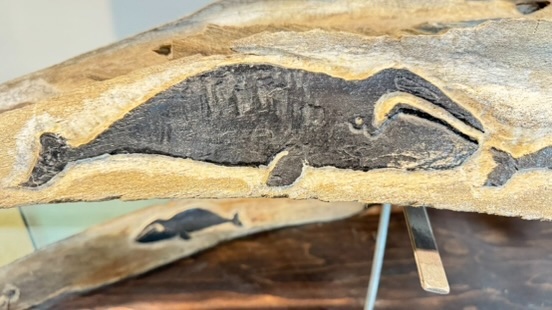
A whalebone rib etched, on its own material, with the bowhead the material came from — an animal that returns, through the carver’s hand, into a portrait of itself. The kind of image the West spent centuries trying to invent a theory of art to permit. Photograph by John J. King II.
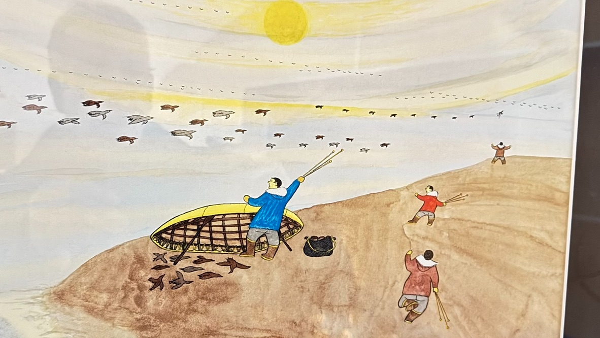
A watercolor from the same tradition: the umiak’s wooden ribs still bare on the gravel, a hunter’s arm raised in the same gesture used to greet a landed whale, skeins of migrating birds strung under an outsized solstice sun. Every element in the frame is on the coast in June, and every element is at work. Photograph by John J. King II, of a piece by an unrecorded North Slope artist.
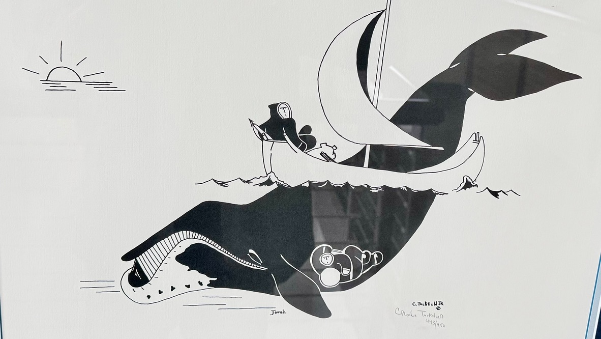
Charles Tuckfield Jr., “Jonah” (edition 443/950). An Inuit hunter rides a small sailed boat above the very whale that swallowed the prophet, the sleeping figure legible inside the whale’s side. It is at once a joke, a scripture, and a piece of coastal metaphysics: the hunter and the hunted sharing one silhouette, the Old Testament rewritten by a people who have actually stood on the beach. Photograph by John J. King II.
These four are what we brought home in place of pelts. They are the country’s literature at its own working latitude, and they are the reason Pam and I no longer regard “conservation” as a self-evident category. The coast has been narrating its own case for four thousand years. The visitor’s obligation is simply to notice, and to bring the notice back south.
IV. The Solstice Returns, and the Common Eider
Utqiaġvik itself, when we arrived, was a town in the plain visual condition of the coast it stands on: a working village of about 4,400 people spread across a low gravel spit between the Chukchi Sea and a lagoon, weathered plywood and shipping containers and cold-storage sheds, the streets still muddy and half-frozen in June, boats hauled up wherever the ground permitted, the sea-ice still gripping the beach in a broken white shelf that would not fully release for weeks. Nothing in the architecture consented to being photographed the way the tundra did. Everything in the architecture insisted, correctly, that it was here because the whales were here. The town is not decoration around the culture. It is the culture's working perimeter.
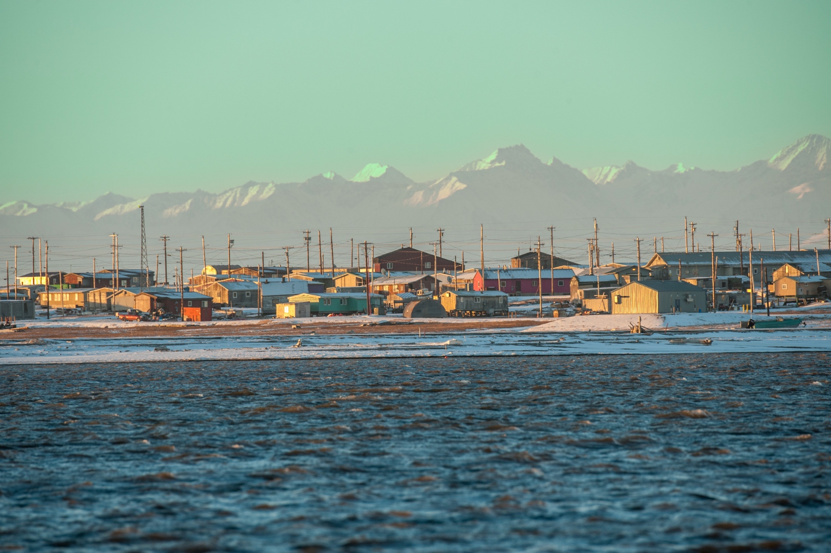
Utqiaġvik at evening in June, the working village on its gravel spit above the Chukchi Sea, the Brooks Range holding position on the far southern horizon: not a town first and a coast second, but a coast first, and a town assembled along it. Long before the plywood and the shipping containers and the roads out to the DEW-line domes, the same ground was the same reason — the whales came here, so the people came here, and the perimeter of a four-thousand-year working culture is what we are, in fact, looking at. Photograph by John J. King II.
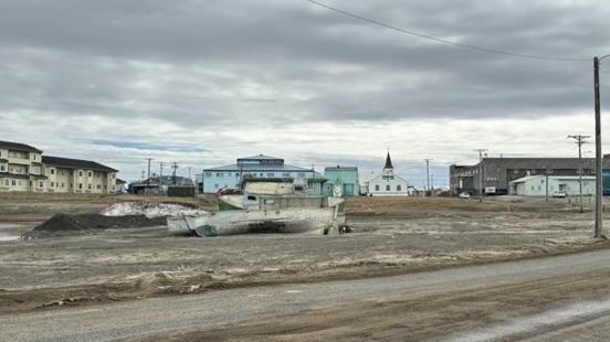
Utqiaġvik in early June: an aluminum whaling boat parked in the gravel where a road becomes a working yard, the blue clapboard church in the middle distance, low houses trailing off toward the lagoon. The town is not decoration around the culture; it is the culture’s working perimeter. Photograph by John J. King II.
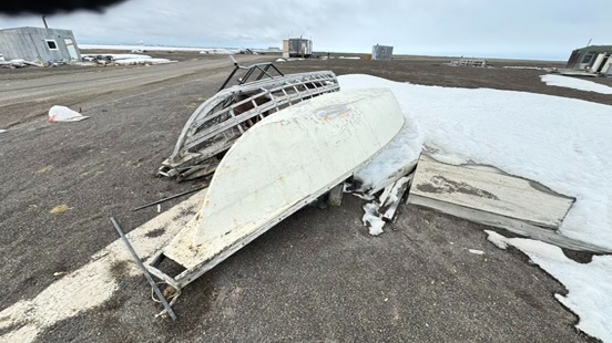
An old hull at the edge of town, its ribs open to the weather. Nothing here consents to being tidied up; the coast keeps what the coast can still use. Photograph by John J. King II.
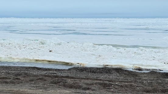
The Chukchi shore in mid-June: dark gravel meeting the still-locked shelf of shore-fast ice — the ice that has organized four thousand years of life here, and that is now, measurably, letting go earlier each spring. Photograph by John J. King II.
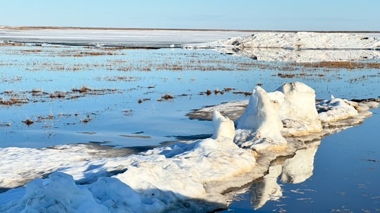
A cluster of ice pinnacles slowly disassembling in a shallow tundra pond outside town, mirrored on water flat as glass. Solstice week, and the ice has begun quietly to negotiate its own terms. Photograph by John J. King II.
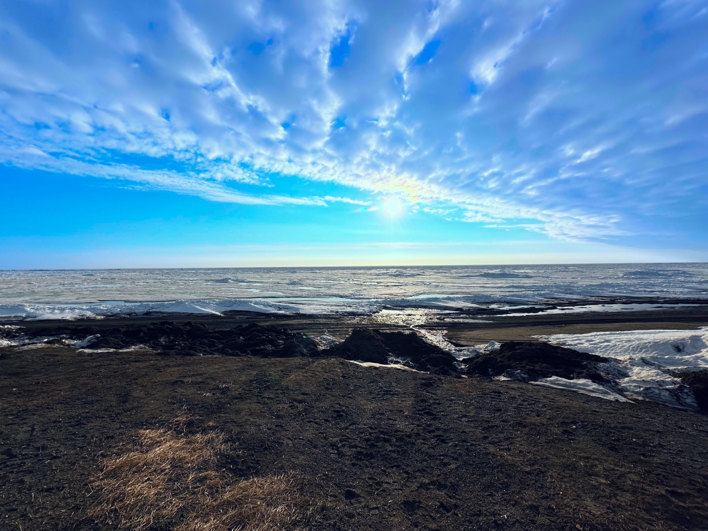
Midnight in Utqiaġvik at the solstice: a sun that will not set, held low over a Chukchi Sea still shelved with broken pans of shore-fast ice. Long before the arch that ritualized this hour and the town that grew up behind it, the sun and the ice were already keeping this appointment. What is new is how much later, each year, the ice now waits for its own release. Photograph by John J. King II.
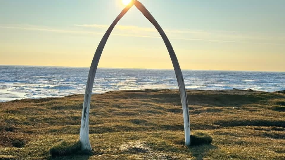
The bowhead jaw-bone arch on the Utqiaġvik shore, framing the midnight sun of the solstice, June 2026. The arch is made of the paired jawbones of a bowhead — the animal that has organized life on this coast for four thousand years — and it holds, at this hour, both the sun that does not set and the sea that will not yet melt.
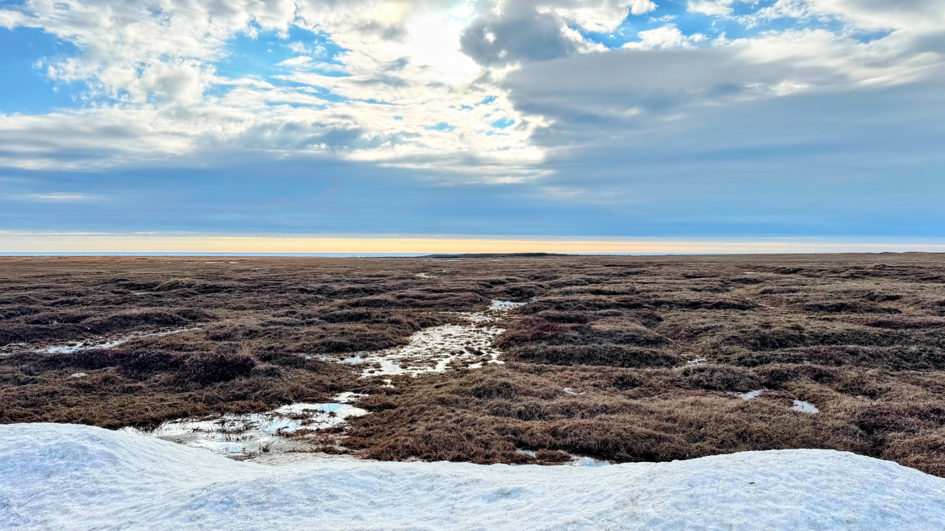
The coastal plain at the solstice: a snowbank still holding on the near ground, the wet brown mat of sedge and cottongrass and dwarf willow running unbroken to a thin white line of the Chukchi on the far horizon, the sky doing most of the work. Pam and I stood on that plain for a long while, saying almost nothing. Long before the roads, the airfield, or the DEW-line domes, this was the shape of the country — flat, honeycombed with ice-wedge polygons under the surface, and lit around the clock in June by a sun that would not consent to set. Photograph by John J. King II.
By the solstice the village had returned to itself, and so, in our smaller way, had we. The light at 71 degrees north simply refused, with a kind of provincial obstinacy, to set. It rolled along the horizon instead, dipping but never quitting, the tundra glowing at midnight under a low copper light that flattened distance and made the polygonal ground — the great honeycomb of ice-wedge cracks that quilts the Arctic plain — look like a tapestry laid flat against the curve of the Earth. We slept badly and gratefully. The light alone was worth the trip.
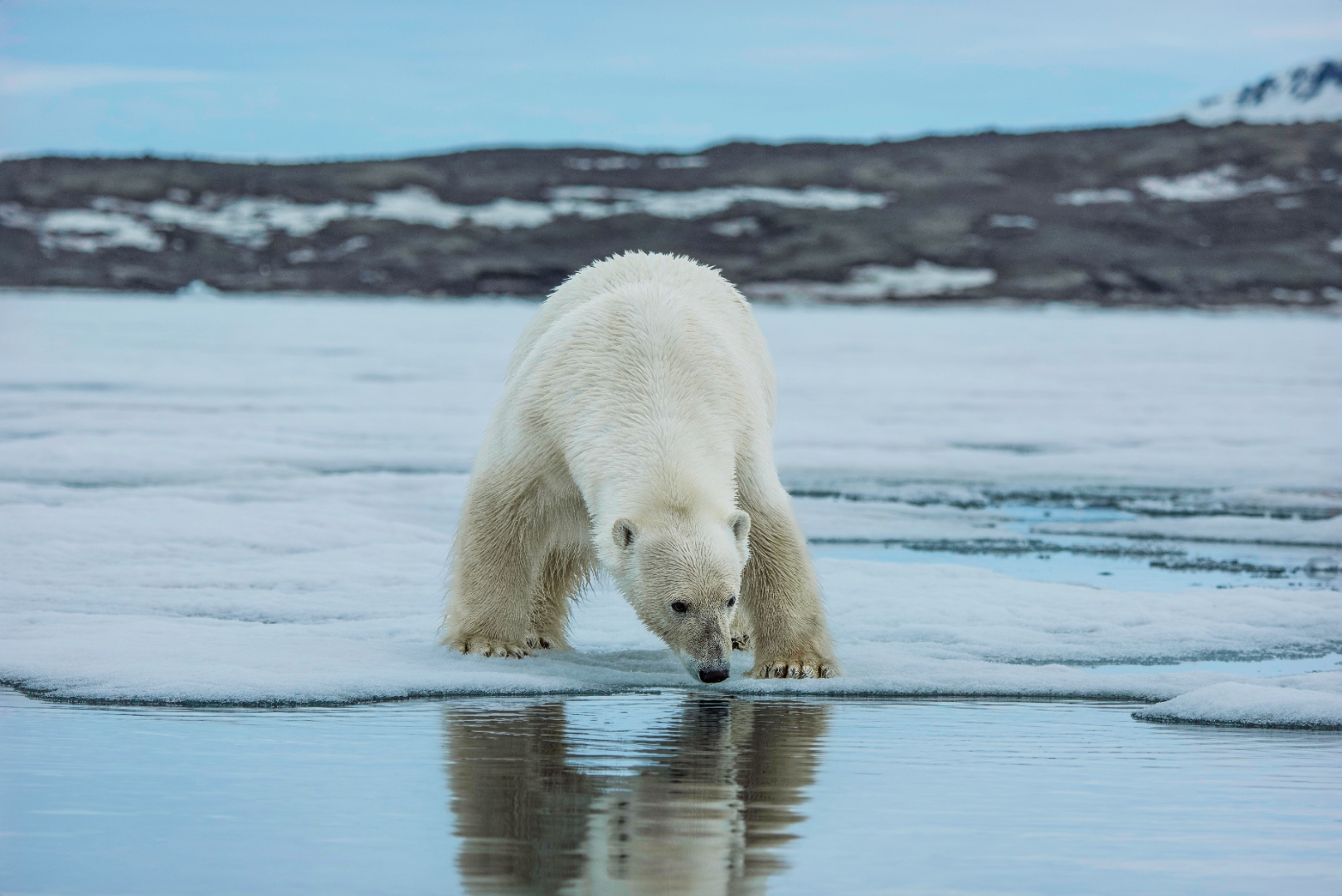
A polar bear (Ursus maritimus) at the melt-water edge in Svalbard, his body and his own reflection doubled in a thin lens of open water where solid ice used to be. The bear is not on the Alaskan coast in this frame; but the physical loss is the same physical loss, and the Barents and Chukchi are the same ocean at different longitudes. Svalbard has warmed at roughly twice the global average, and the shore-fast ice that has organized four thousand years of northern life is, on both sides of the pole, letting go earlier each spring — which is what "letting go earlier" actually looks like when you stand at the edge of it. Photograph by John J. King II.
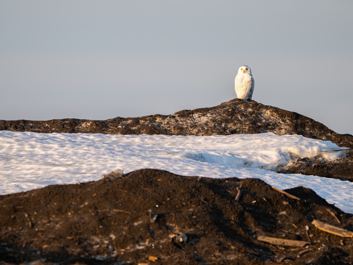
Snowy owl on a tundra hummock outside Utqiaġvik, June, in low midnight light. The Iñupiaq name Utqiaġvik means “a place where snowy owls are hunted.” Photograph by Ben Stephens.
We found three snowy owls in that endless daylight, all within a few miles of Utqiaġvik, and each of them, in a way I am still trying to work out, was a small lesson in attention — and in the country's particular trick of presenting its wonders against backdrops the brochures would prefer to crop out. The first was barely a sighting at all: a heavy white shape that broke from the tundra at the moment the trailing vehicle came over a rise, passed across our windshield once at the height of a man's chest, and then beat steadily away over the open ground until the horizon swallowed it. We did not even have time to lift a camera. The Arctic, having performed the introduction, declined an encore.
The second was a near-pure white male, and we found him, of all places, presiding over the village garbage dump — perched high on a large rusting metal container amid a small empire of failing infrastructure, the steel and the bird both gone the same flat white in the low solstice glare. Several of our party set out across the mud and the standing tundra pools to get a closer look, which is the kind of suffering one will accept for a snowy owl and would accept for very little else, and the owl, having let them work through a hundred yards of cold water in their boots, lifted unhurriedly and flew another quarter mile, landing this time among the great DEW Line radar domes that still stud the coast like enormous golf balls left behind by the Cold War — geodesic relics of a war that never quite happened, repurposed now, in the bird's view, as perches. There was something almost embarrassingly American about the tableau: a creature of the high Arctic posed against our junk and our paranoia, indifferent to both.
The third put on the show, and the show was the lesson. A male quartering low over the cottongrass dropped abruptly, talons forward, into a patch of sedge and came up with a brown lemming kicking in his foot — a clean, silent transaction repeated, one supposes, a hundred million times across this coast, and the engine, in the end, of every snowy owl breeding season on Earth. In big lemming years the owls nest in numbers; in poor ones they barely nest at all, or skip the Arctic entirely and irrupt southward in winter to the alarm and delight of birders in Massachusetts and Washington alike. We had been fortunate to see snowy owls on Cape Cod on a couple of such occasions in the last decade. But to see one here, on his own ground, hunting in light that never failed, was to see him whole, which is the privilege one travels to the top of the world to claim.
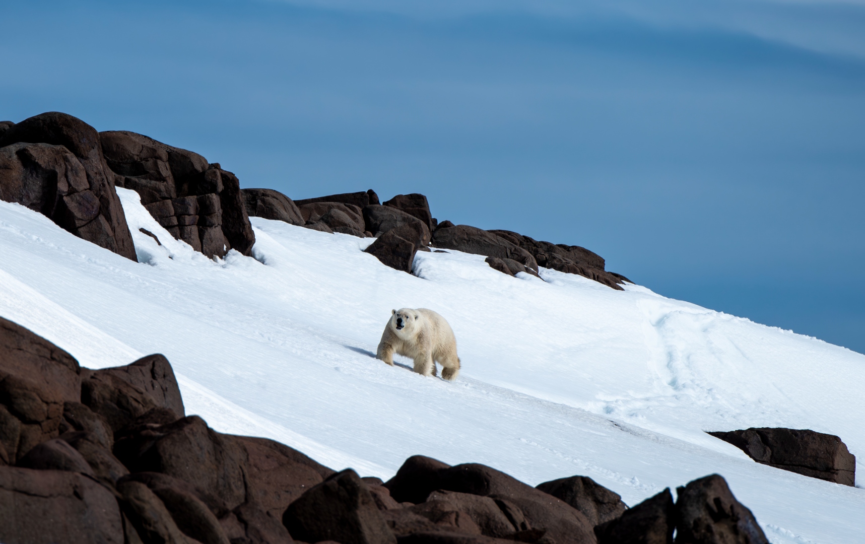
A polar bear (Ursus maritimus) crossing a spring snow slope in the high Arctic, dark rock outcrops breaking through the white behind him. The snowy owl is not the only sovereign of this ground: the same tundra that funnels lemmings under the owl’s talons carries, at a heavier register, the tracks of the bear. Long before Utqiaġvik was Utqiaġvik, both animals were already reading this country — the owl by the year’s rodents, the bear by the year’s ice — and the reading, on both counts, is now being rewritten under them. Photograph by John J. King II.
The Iñupiaq name Utqiaġvik means "a place where snowy owls are hunted," and standing on that tundra it was impossible not to feel how exactly the name fit the country: the owls were not metaphor or mascot but a real, renewable presence, woven into a food web the Iñupiat have read fluently for four millennia and that the rest of us are only now beginning, with embarrassing slowness, to learn how to read at all. Yet even as the Iñupiat reclaim language and governance, the physical world that food web depends on is changing faster than almost anywhere on Earth. Arctic temperatures are rising more than twice the global average; three-quarters of summer sea ice has already vanished; December averages in Utqiaġvik have climbed nearly five degrees Fahrenheit in two decades. Multiyear ice thick enough to butcher a landed whale on is disappearing, and the predictable spring leads that funnel bowheads past hunting camps are growing erratic, which is to say that the whales and the people who have hunted them are losing, at the same time, the same address (The Guardian).
The same ice loss is pushing the polar bears toward crisis. In the southern Beaufort Sea, where ice-free periods have lengthened sharply, the populations have declined; sea ice loss is the species' primary threat under the Endangered Species Act, and there is no genuine version of the polar bear's future that does not begin with sea ice (Polar Bears International). On land, melting permafrost and unbuffered fall storms are simply eating the coastline. The federal government has formally identified Kivalina, Shishmaref, and Newtok as imminently threatened villages whose residents must relocate — a process that has crawled forward for more than two decades against staggering cost, jurisdictional confusion, and the kind of national distraction that allows whole human communities to fall, very nearly, out of the country's peripheral vision.
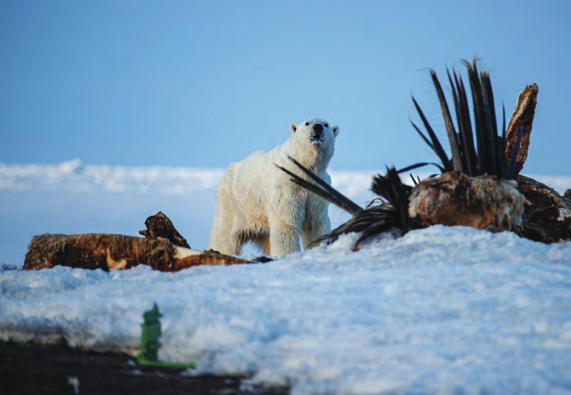
A polar bear walking past the community bone pile at Utqiaġvik — the vertebrae and skull plates of butchered bowheads returned, according to old obligation, to the edge of the sea. The bear and the whale share a coast; the ice that has always joined them is measurably retreating. Photograph courtesy of Alaska Arctic Observatory & Knowledge Hub.
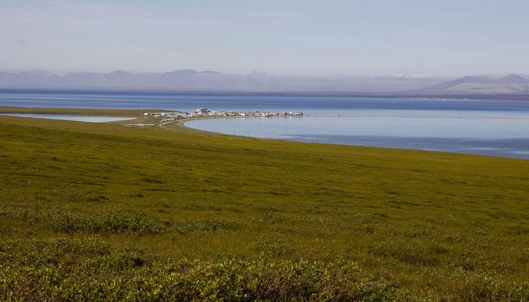
A North Slope village seen from a low bluff above — the whole community held between two arms of water, its long axis parallel to the coastline that is quietly retreating beneath it. Kivalina, Shishmaref, Newtok: these are not the exceptions but the leading edge. Photograph by Eric Gauger, "Midnight in Beringia".
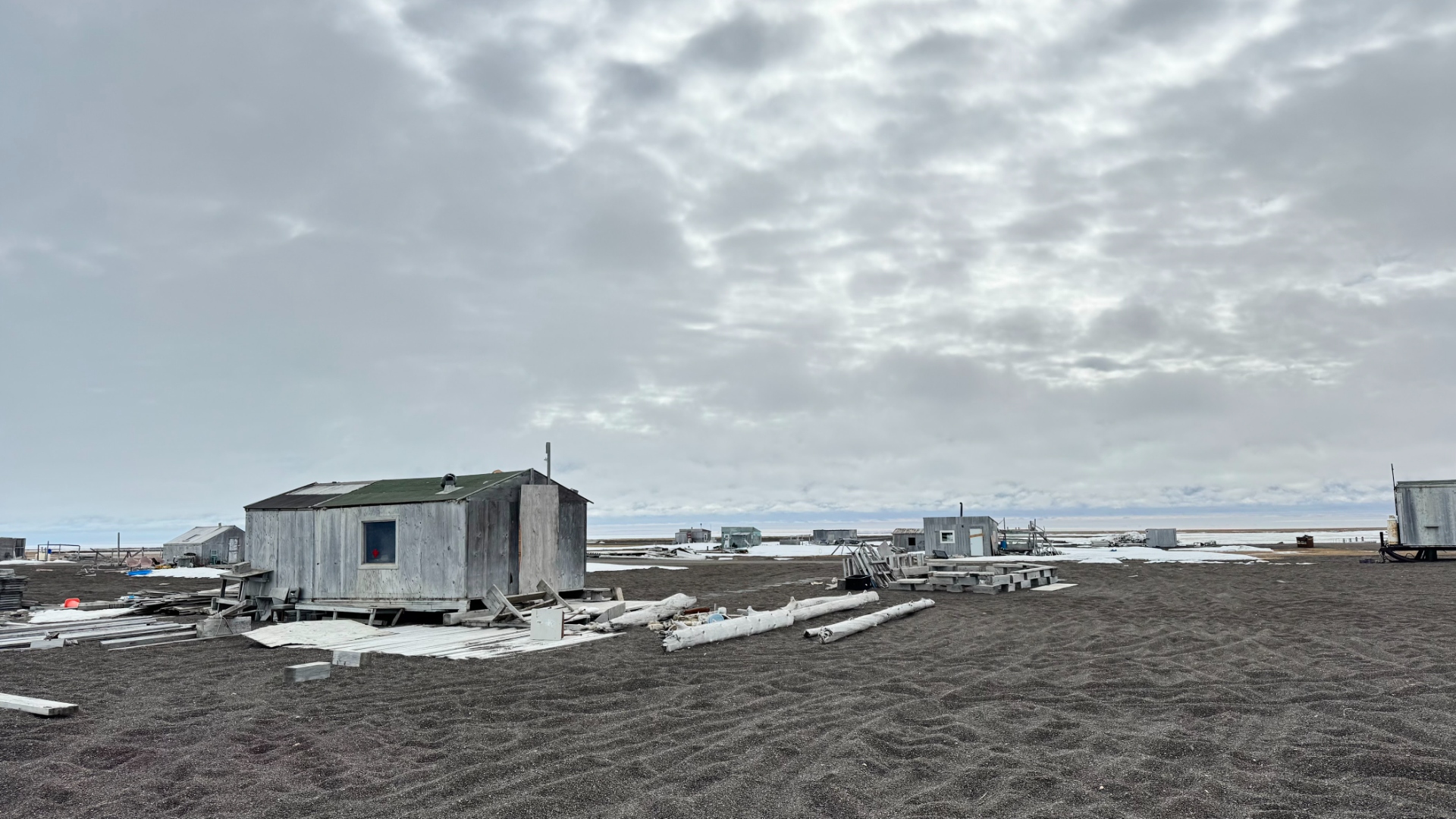
A cabin still standing on the black-sand beach at Utqiaġvik — the kind of small, unsentimental structure the coast keeps producing and the coast keeps taking back. Each fall storm now arrives on water that used to be ice; the beach in front of the door narrows a little further each year. Photograph by John J. King II.
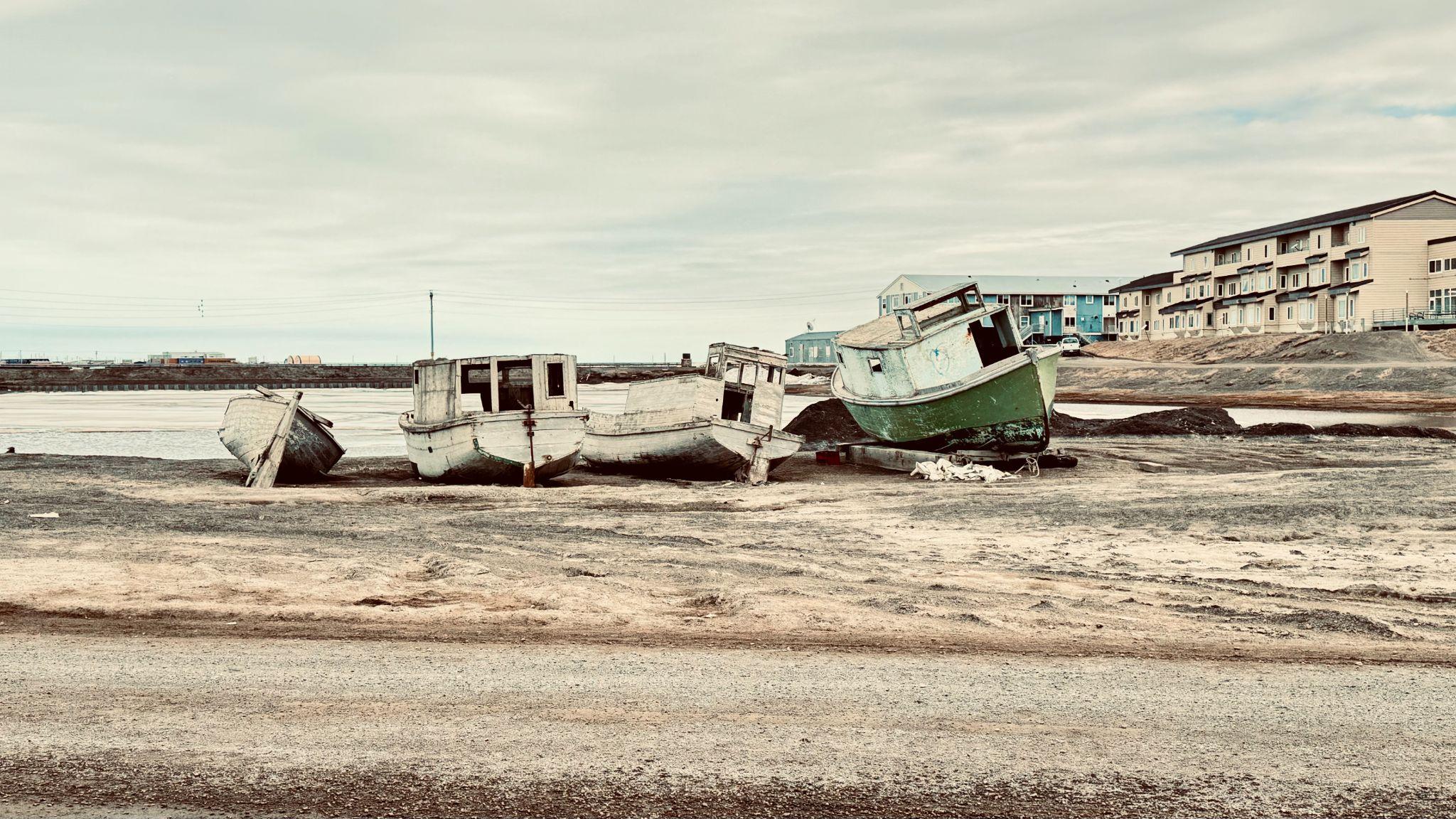
Two working boats reduced to weathered ribs on the Utqiaġvik shore, the village behind them. Nothing here is discarded; each hull carries the tally of what the ocean has already asked of the community, and of what it will keep asking. The federal government has formally named Kivalina, Shishmaref, and Newtok as imminently threatened; Utqiaġvik itself is not yet on that list, but the arithmetic on this beach is not encouraging. Photograph by John J. King II.
The threat is not abstraction on a graph. It is boats, and cabins, and the beach in front of a door. Long before Kivalina and Shishmaref and Newtok became names on a federal register of imminently doomed villages, they were addresses where families kept skiffs and coldstorage sheds and the quiet infrastructure of a coastal life; a life the sea is now, one storm at a time, taking back.
There is a duck that has not yet appeared in this account, and the reason for the omission is that she belongs to the close. The common eider is, as her name suggests, the bird at home. Pam and I have watched her, on a far Russian coast some years before this trip — the storm-beaten shingle of a Chukchi island above the Bering Strait, in the summer of 2008 — sitting on a clutch of eggs inside a driftwood frame someone had propped, long before her arrival, against the wind. She was so exactly the color of the beach cobble that we nearly stepped on her before realizing she was there: a quiet, brown, perfectly invisible hen against ground the same brown, the down at her breast already plucked to line the shallow bowl in which her ducklings would shortly arrive. The drake we saw separately, in low flight above the sedge farther inland, patchy black and white against the brown ground, moving with the unhurried, straight-lined purpose of a bird built for cold water and bottom-dwelling shellfish and the slow, patient work of staying alive at high latitude.
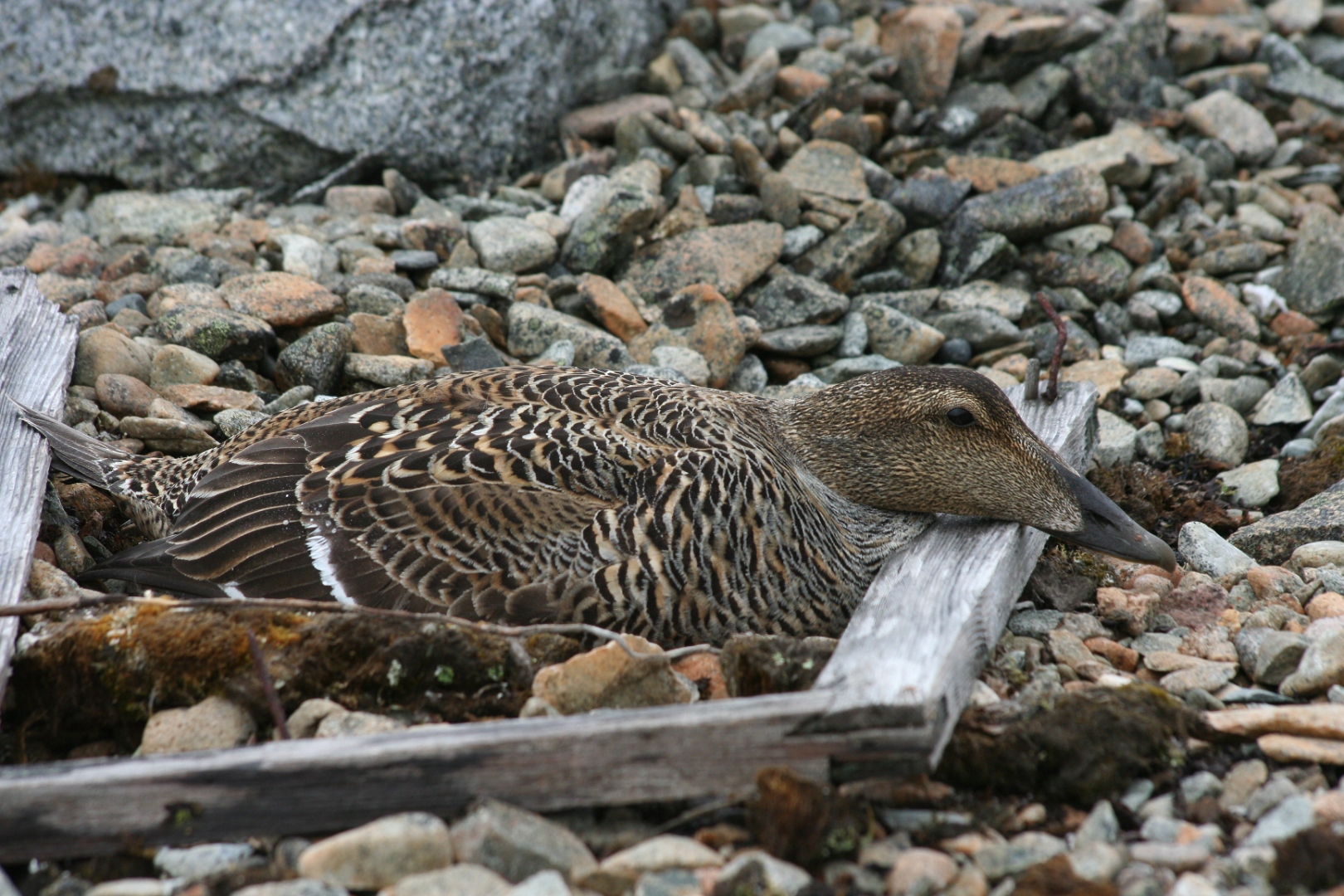
A common eider hen on her nest, Chukotka, June 2008. She was so exactly the color of the beach cobble that we nearly stepped on her before realizing she was there. Photograph by John J. King II.
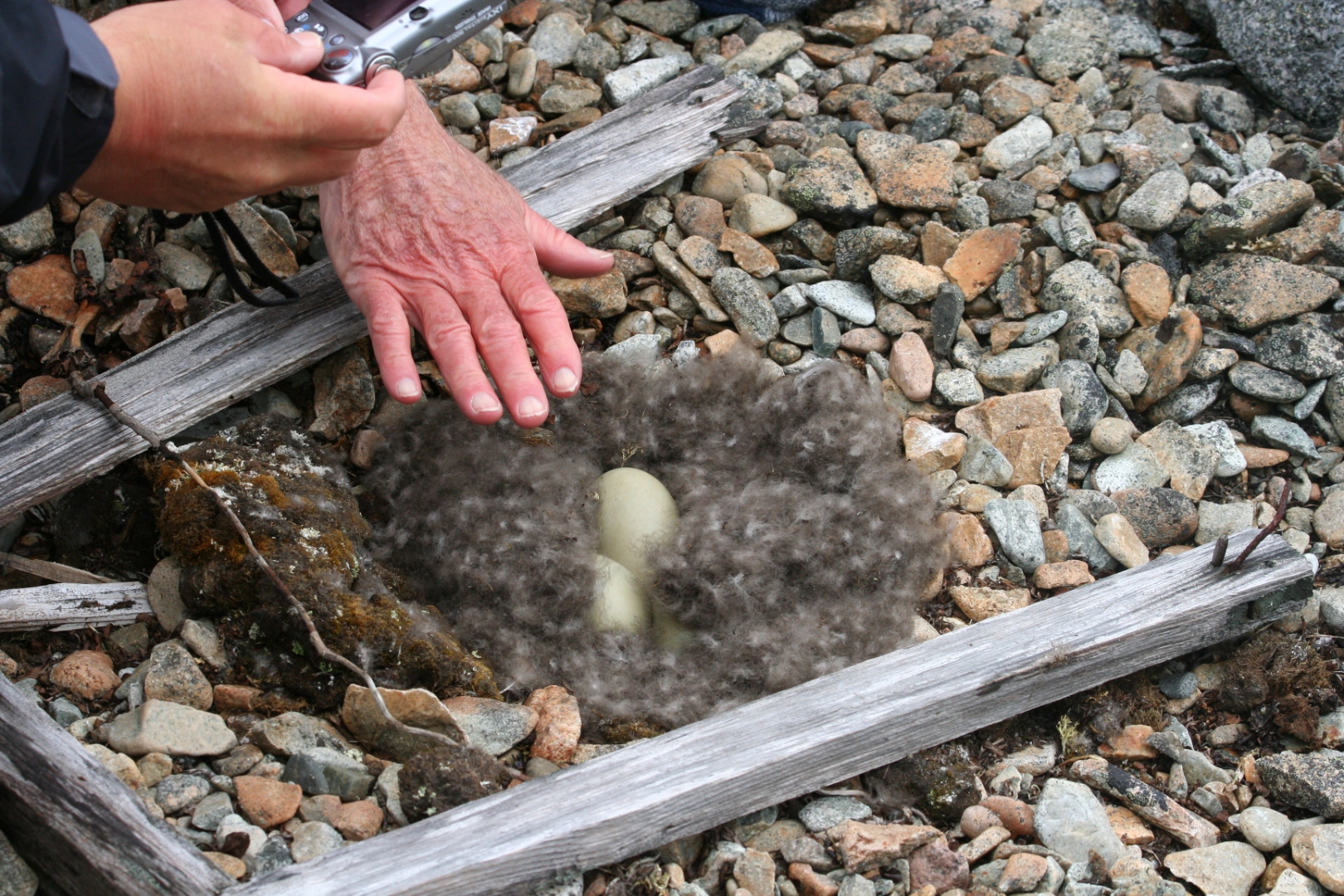
The same nest after the hen briefly stepped off. The bowl is lined with down plucked from her own breast; the eggs are the pale olive of the species, still warm to a hand held above them. Photograph by John J. King II.
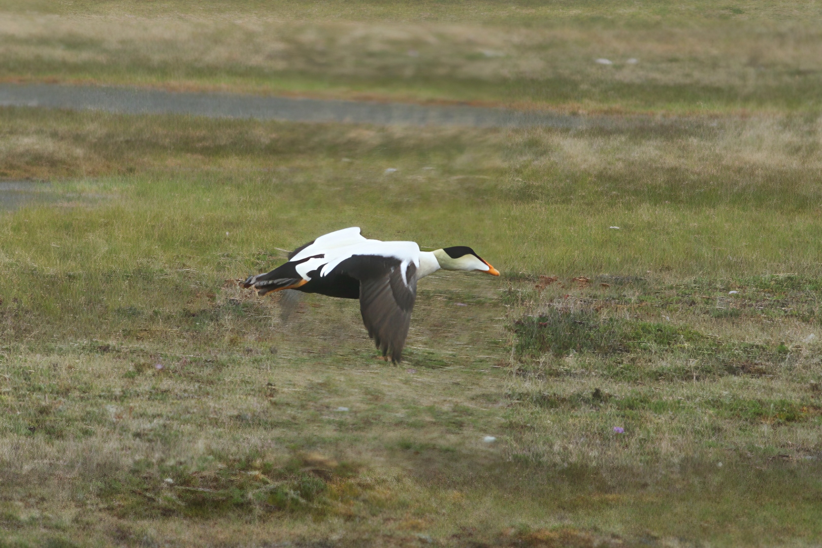
The drake, seen the same June inland of the nest, in low flight over Chukotka tundra. The same species winters, four thousand miles east, in rafts off Cape Cod. Photograph by John J. King II.
What I had not understood, until I began to put the trip together with the rest of our lives, was that the common eider is also the bird that comes home to us. Each autumn, beginning in September and continuing into November, common eiders from the Maritime and Greenland populations move south along the New England coast and assemble in great wintering rafts off Cape Cod — tens of thousands of birds working the shellfish beds off Monomoy, Chatham, the back side of Nauset, the cold gray waters where my own ancestors made their lives. They stay until April or early May, and then they go back to the Arctic to begin again. The bird Pam and I had watched on her invisible nest on that Chukchi shingle was, in the most literal sense one can mean it, a bird whose family winters off the kitchen window of my ancestral home.
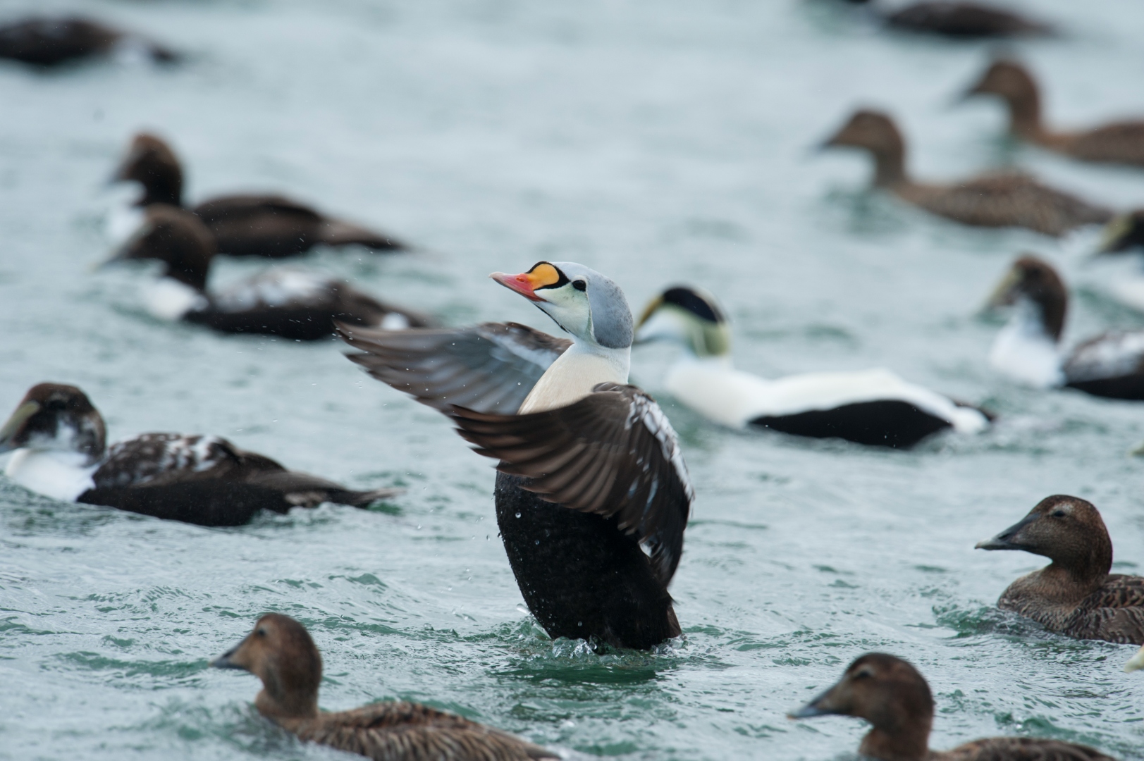
A king eider drake — Somateria spectabilis, a proper Arctic vagrant this far south — riding the Cape Cod Canal in the last days of March 2013, among thousands of common eiders staging in that narrow, tide-driven cut before the long lift north. Long before I knew to call this a rare bird, it was already an ordinary Bering bird taking the long way home; what was rare was only my angle on it. Within a week, most of these commons would be gone from Cape Cod, working the same latitudes as the ice, on the way to the shingle where Pam and I would find their sisters on the nest five years later. Photograph by John J. King II.
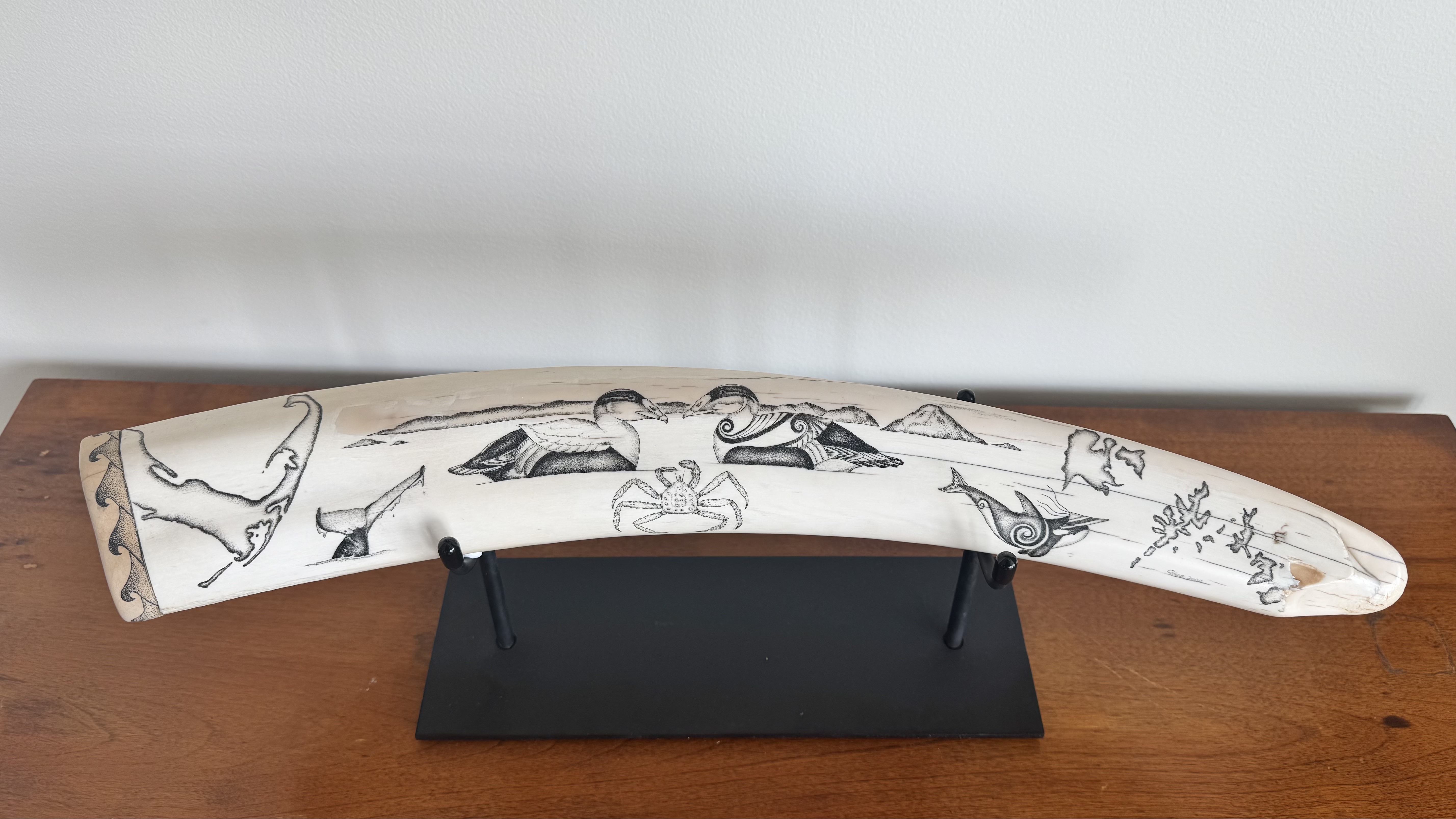
Ivory from the same seas that raised the birds: a walrus tusk, engraved in fine stipple by the Homer scrimshander Conrad Field, and given to Pam and me to mark the more than fifty years since we first met at Sand Point, in the Shumagin Islands, on the far side of the continent from where either of us started. Two common eiders greet each other over an Alaska king crab, the coastlines of Alaska and Cape Cod flanking the composition — the same bird, the same crab, and the same distance the eiders themselves fly twice each year between the Bering and Massachusetts Bay. Long before the tusk became art, it was tooth, and animal, and food; long before Pam and I met in a Wakefield seafood plant, the eiders were already commuting between our two coasts. The engraving only tallies what the birds and the ivory had been carrying all along. Photograph by John J. King II.
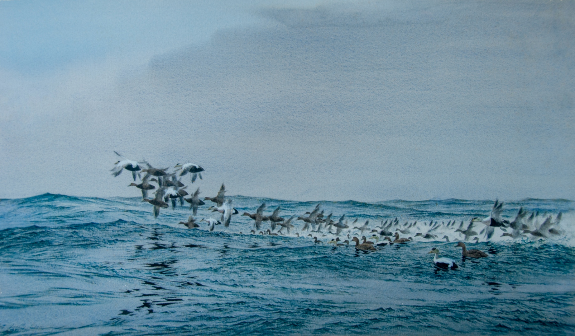
Common eiders taking flight off Chatham, Massachusetts, in winter. Watercolor by Robert Verity Clem. The rafts assembling each January off Cape Cod are the same population — the same individuals, some of them — nesting on the Chukchi coast six months earlier.
This is the news the eider brings. The Arctic is not somewhere else. It is the place from which the birds we have always called ours each winter actually come, and to which they each spring return, and the warming of which is the warming of our own coast at a quieter latitude. The Iñupiat and the Chukchi have understood this for four thousand years because they have lived on the hinge of it. The rest of us are being taught it now, slowly, by the birds themselves — bird by bird, latitude by latitude, autumn by autumn. Pam and I are being taught it too, later than we should have been, in the company of common eiders riding a Cape Cod swell that is, against the long arithmetic of the planet, the same swell that lifts and lowers the half-rimmed pond at Utqiaġvik. We are all on the same coast. The eider has been trying, patiently, to tell us.
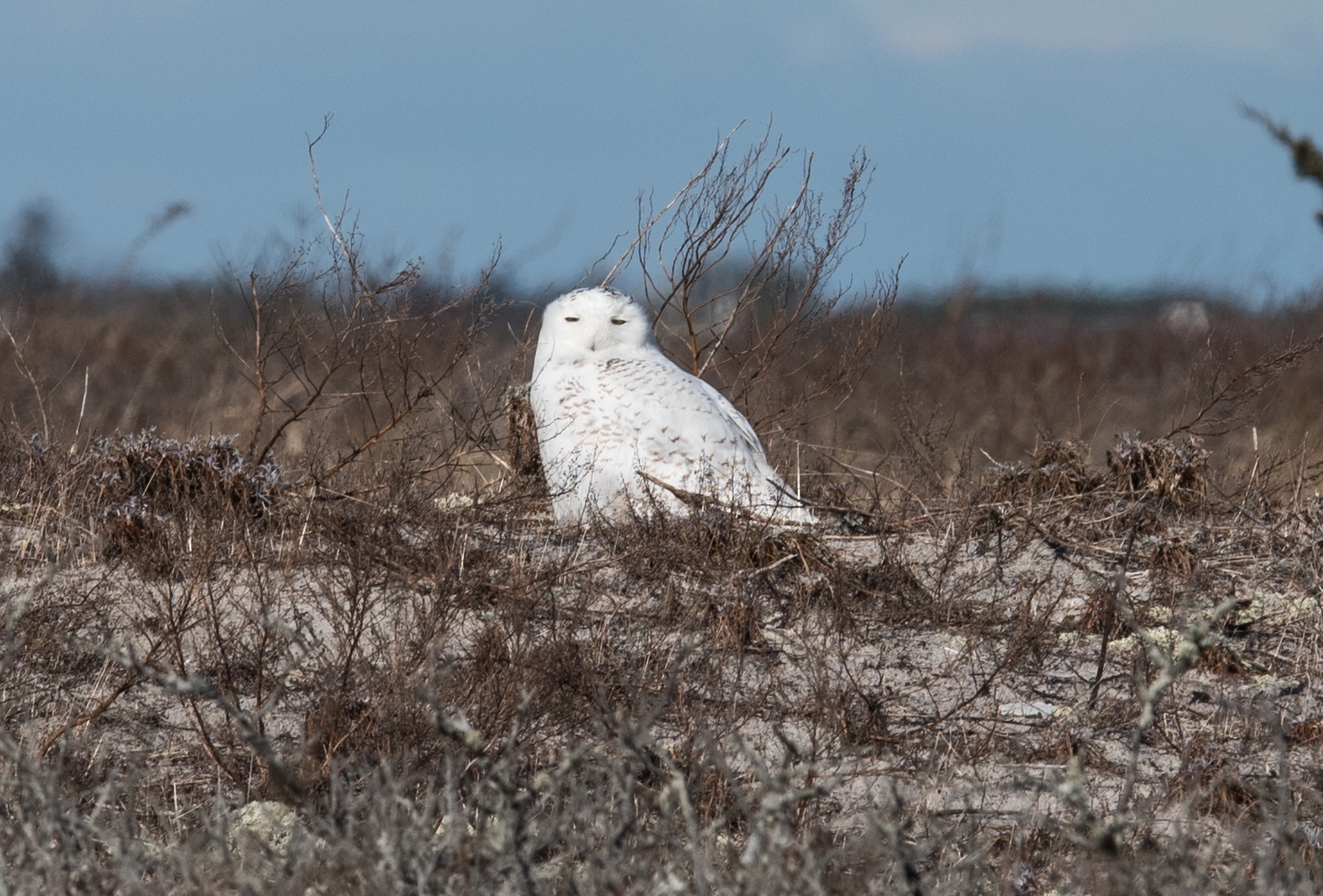
A young snowy owl — Bubo scandiacus — bedded down in the dune-heath and beach grass at Chatham, in one of the great irruption winters when a failed lemming year on the tundra sends a generation south along the coasts. Long before the birders arrived with cameras and the whispered pass-along of coordinates, the owl was simply resting in the country she had been given, at 41° north instead of 71°. The Arctic, this coast keeps insisting, is not somewhere else. Photograph by John J. King II.
For a traveler arriving by small plane to watch a gyrfalcon's chicks shoulder into the wind, or by boat to watch puffins circle the cliffs of Kenai Fjords, it is tempting — almost obligatory — to treat this country as scenery, the way Americans have always preferred to treat the parts of America that are inconvenient to live in. The Iñupiat ask something more demanding. They ask us to see Nome and Utqiaġvik as living places where a four-thousand-year-old culture is simultaneously healing from colonization and bracing against a warming sea, and to understand that the migrating birds, the bowheads, the bears, and the people who have always shared this coast now share, whether the rest of us wish to notice it or not, the same precarious future. The gyrfalcon over her chicks at the cliff scrape did not, of course, know any of this. She was simply doing what gyrfalcons have done in this wind for as long as the wind has blown. It will be on us — the people who came north with scopes and notebooks and the small private fortunes that purchased the trip — to know it for her.
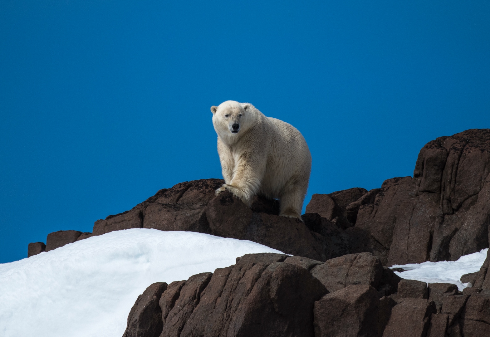
A polar bear (Ursus maritimus) on a bare rock ridge under a deep blue high-Arctic sky — the sovereign witness of the coast the essay has just finished naming. The migrating birds, the bowheads, the bears, and the people who have always shared this ground are, in the longer ecological ledger, on one account; the bear on his ridge, alone against a horizon that used to be ice, is what that account looks like when it is drawn down without being repaid. Photograph by John J. King II.
One hundred and forty-one. That is the number our group brought home from twelve days in the country, dutifully ticked, dated, and geolocated in the damp notebooks that birders carry the way pilgrims once carried beads — a tally that, by the standards of the activity, is a respectable haul, and that I have caught myself, on more than one cold morning since, totting up again as if the number itself were the trip. It is not. The number is the trophy a list-keeping species awards itself for having been briefly present. The trip was the gyrfalcon over her chicks beneath the bridge, and the spectacled eider pair tracking the slow clock of the melting ice in the company of loons, and the snowy owl on the radar dome, and the bowhead-flag flying over a captain's house in Utqiaġvik because the obligation had not yet been honored, and the Lorino children moving through the work with strips of fresh blubber in their hands. The trip was Pam and I learning, late in lives spent imagining we already knew, that the Iñupiat and the Chukchi have been keeping a different kind of list for four thousand years — one in which a successful season is measured not by what is brought home but by how much of it is given away. The bird list and the whale list do not, on the page, look like the same document; they are, I have come to think, the same document read at different latitudes. What is asked of those of us who fly in with scopes is not a longer list. It is a willingness to see Kivalina and Shishmaref and Newtok as the leading edge of an arithmetic the rest of the continent will eventually have to do, and to spend, on their behalf and on the bird's, whatever portion of our remaining attention the country still permits us to give. The eider is not waiting for us to decide. She is already flying.
Illustration Credits
A working list of the photographs, maps, and reproduced artworks that appear in this essay, grouped by maker. Where wording is still to be confirmed with the source, the entry is marked pending.
Photographs by Pam King
Reproduced with permission from Pam King.
• Landed gray whale on the gravel beach at Lorino, Chukotka, June 2008.
• Priestess and acolyte offering thanks on the whale’s flank, Lorino, June 2008.
• Ceremonial dancer during the afternoon celebration, Lorino, June 2008.
• The gray whale flensed in mid-afternoon, Lorino, June 2008.
• Loading maktak into a family bucket, Lorino, June 2008.
• Whalebone graveyard on a Chukchi bluff above the Bering Strait, Little Diomede visible on the horizon.
Photographs by John J. King II
All images not otherwise credited are the author's own. Notable figures include:
• Polar bear on the snow-and-gravel shore at Kaktovik, Beaufort Sea coast (lead figure).
• Polar bear at the melt-water edge, Svalbard (context photograph for the sea-ice section).
• Polar bear on a spring snow slope, high Arctic.
• Polar bear on a rock ridge under deep blue sky, high Arctic.
• Utqiaġvik at evening: the village and the Brooks Range on the horizon, June 2026.
• Midnight sun over the Chukchi from Utqiaġvik, solstice, June 2026.
• North Slope tundra at the solstice: coastal plain, snowbank foreground, Chukchi on the far horizon.
• Female gyrfalcon at the cliff scrape, near Nome, June.
• Gyrfalcon lifting from the slate outcrop, near Nome.
• Solitary whimbrel on the Grays Harbor mudflats, Washington, late April.
• Hudsonian whimbrels on the Seward Peninsula tundra, June.
• Steller’s eider drakes lifting from Varangerfjord, Kirkenes, northern Norway, winter.
• Spectacled eider pair on an ice-rimmed Utqiaġvik tundra pond, June.
• The loon pond outside Utqiaġvik: spectacled eider pair and Pacific loons on open water, receding ice pans behind, NARL radome on the horizon.
• Pacific loon pair in breeding plumage, Utqiaġvik tundra pond.
• Iñupiat bowhead etched into whalebone rib (gallery photograph).
• “Top of the World” baleen scrimshaw triptych, signed FLS (gallery photograph).
• Walrus tusk engraved with an eider motif, by Conrad Field of Homer, Alaska (gallery photograph of a commissioned piece owned by the author).
• King eider drake among common eiders, Cape Cod Canal, March 29, 2013.
• Young snowy owl on the Chatham dune-heath, January 6.
• Wrecked boats along the Utqiaġvik shore.
• Umiak, sun, and migrating birds — watercolor by an unrecorded North Slope artist (gallery photograph).
• Charles Tuckfield Jr., "Jonah" (edition 443/950), gallery photograph.
• Nome driftwood beach at low tide.
• Utqiaġvik in early June: aluminum whaling boat, blue clapboard church, low houses.
• Old hull at the edge of Utqiaġvik.
• Cabin still standing on the black-sand beach, Utqiaġvik.
• Chukchi Sea shore-fast ice shelf at Utqiaġvik, mid-June.
• Ice pinnacles in a tundra melt pond outside Utqiaġvik, solstice week.
• Common eider hen on her nest inside a driftwood frame, Chukotka, June 2008.
• Common eider nest and eggs, Chukotka, June 2008.
• Common eider drake in low flight over Chukotka tundra, June 2008.
• Safety Roadhouse on the Council Road east of Nome.
Photographs and maps by Eric Gauger
Reproduced with permission from Eric Gauger, Midnight in Beringia. Permission wording to be finalized with the author prior to publication.
• Seward Peninsula orientation map (map).
• Village from the bluff, North Slope (photograph).
• Abandoned gold dredge outside Nome (photograph).
• Working shack on the Nome road system (photograph).
• Small wooden rowboat pulled up in tall tundra grass, golden hour (photograph).
• Braided tundra river meandering across the Seward Peninsula plain (photograph).
Photographs by Joan Tell
Reproduced with permission from Joan Tell.
• The Steller’s eider decoy nestled among tundra wildflowers, near Nome.
• Birder with spotting scope on the tundra, outside Nome.
Alaska Arctic Observatory & Knowledge Hub (AAOKH)
Permission and wording to be confirmed with AAOKH prior to publication. Current interim wording reads "courtesy of Alaska Arctic Observatory & Knowledge Hub." Institutional affiliation (University of Alaska Fairbanks) and project or PI credit lines to be added upon confirmation.
• Winds and sea-floor bathymetry off Utqiaġvik and Point Barrow (map).
• Sealskin umiak with crew flag at the edge of the shore-fast ice (photograph).
• Sealskin umiak at the ice edge, hunter beside it (photograph).
• Polar bear walking past the community bone pile, Utqiaġvik (photograph).
Photographs by Valerie Lake / Alaska Public Media
Reproduced with permission from Alaska Public Media. See the original 2024 feature. Formal permission letter on file (to be confirmed prior to publication).
• The flag of the Aaluk Crew, Utqiaġvik.
• Quincy Adams butchering bowhead in his kitchen, morning after the 2024 spring landing.
Robert Verity Clem
Estate permission required prior to publication. Currently reproduced under fair-use review for pre-submission manuscript circulation only.
• Common eiders taking flight off Chatham, Massachusetts (watercolor).
Photographs by Lina Grube
Reproduced with permission from Lina Grube.
• King eider flock in flight over the Bering Sea.
Photographs by Ben Stephens
Reproduced with permission from Ben Stephens.
• Snowy owl on a tundra hummock outside Utqiaġvik.
U.S. Fish and Wildlife Service
Public-domain federal work. No permission required; attribution provided for accuracy.
• Spectacled eider historical vs. current breeding range map.
A Note on Permissions
This manuscript is circulating in draft form for editorial review. Final publication will follow written permission from each rights holder, and any image whose attribution cannot be resolved will be replaced or removed prior to submission. The author is grateful to the photographers, mapmakers, and institutions whose work makes the essay possible — the coast is, among other things, a document collectively kept.
U.S. Fish and Wildlife Service, Spectacled Eider (Somateria fischeri) species page; W. Larned et al., Spectacled Eider Pacific Population Status Report, USFWS Migratory Bird Management.↩︎
U.S. Fish and Wildlife Service, Spectacled Eider Recovery Plan (Anchorage, 1996); USFWS species page, op. cit.↩︎
USFWS species page, op. cit.; 58 Fed. Reg. 27474 (May 10, 1993), final listing rule.↩︎
U.S. Fish and Wildlife Service, Spectacled Eider Identification and Avoidance Guidance for North Slope and Y-K Delta Operations (Anchorage Field Office, June 21, 2012).↩︎
CRW Flags / Flags of the World, Barrow / Utqiagvik, Alaska (U.S.).↩︎
Heartbeat Alaska, "Barrow, A Village of Whalers," YouTube.↩︎
S. Akasofu and N. Yamauchi, Aboriginal Subsistence Whaling in Barrow, Alaska, PDF.↩︎
Nalukataq, Wikipedia (citing Charles D. Brower); NOAA Fisheries, "A Voyage Through the Arctic".↩︎
International Whaling Commission, Description of the USA Aboriginal Subsistence Hunt: Alaska.↩︎